Iordăcheanu elevation
Iordăcheanu (Prahova, Comuna Iordãcheanu), Romania elevation is 148 meters and Iordăcheanu elevation in feet is 486 ft above sea level [src 1]. Iordăcheanu is a seat of a second-order administrative division (feature code) with elevation that is 104 meters (341 ft) smaller than average city elevation in Romania.
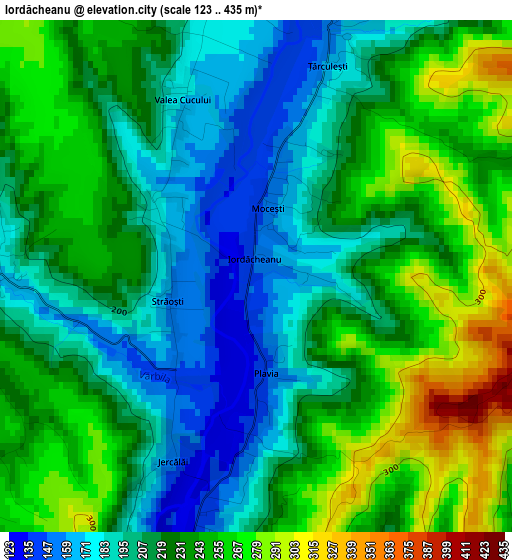
Below is the Elevation map of Iordăcheanu, which displays elevation range with different colors. Scale of the first map is from 123 to 435 m (404 to 1427 ft) with average elevation of 223.9 meters (=735 ft) [note 1]
These maps also provides idea of topography and contour of this city, they are displayed at different zoom levels. More info about maps, scale and edge coordinates you can find below images.
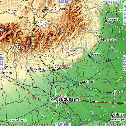
| \ | Map #1 | Topo.Map |
| Scale [m] | 123..435 m | × |
| Scale [ft] | 404..1427 ft | × |
| Average | 223.9 m = 735 ft | × |
| Width | 6.9 km = 4.3 mi | 221 km = 137.3 mi |
| Height | 6.9 km = 4.3 mi | 220.9 km = 137.3 mi |
| ↑Max Latitude | 45.074962° | 46.0289° |
| Latitude at center | 45.04392° | 45.04392° |
| ↓Min Latitude | 45.012861° | 44.04169° |
| ← Min Longitude | 26.195255° | 24.83295° |
| Longitude center | 26.2392° | 26.2392° |
| →Max Longitude | 26.283145° | 27.64545° |
Nearby cities:
Cities around Iordăcheanu sort by population:
• Urlaţi elevation 125 m
6.8 km,  183°
183°
• Ceptura de Sus 222 m
6.8 km,  116°
116°
• Moceşti 212 m
1.1 km,  51°
51°
• Podenii Noi 206 m
9.9 km,  324°
324°
• Gornet-Cricov 241 m
4.9 km,  26°
26°
• Ceptura de Jos 168 m
7.4 km,  110°
110°
• Plopu 181 m
7.6 km,  246°
246°
• Loloiasca 122 m
9.4 km,  154°
154°
• Vărbila 191 m
3.3 km,  275°
275°
• Tătaru 420 m
9.7 km, 49°
• Valea Dulce 178 m
8.2 km,  342°
342°
• Valea Cucului 169 m
2.5 km, 339°
Multilingual:
 En español:
Iordăcheanu elevación 148 m.
 En France:
Iordăcheanu élévation 148 m.
 Auf Deutsch:
Iordăcheanu höhe über dem Meeresspiegel ist 148 m.

Sources and notes:
- [note 1] Map square and city borders are not equal. Map elevation data is calculated only from area inside that square.
- [src 1] Elevation data from geonames database provided with same terms of usage.
- [src 2] The elevation map of Iordăcheanu is generated using elevation data from NASA's 3 arcsec (90m) resolution SRTM data.
- [src 3] Base (background) map © OpenStreetMap contributors tiles are generated by Geofabrik and OpenTopoMap.
Copyright & License:
This Iordăcheanu Elevation Map is licensed under CC BY-SA. You may reuse any part from this page, if you give a proper credit by linking to this URL:
 More info on terms of use page.