Certeju de Sus elevation
Certeju de Sus (Hunedoara, Comuna Certeju de Sus), Romania elevation is 279 meters and Certeju de Sus elevation in feet is 915 ft above sea level [src 1]. Certeju de Sus is a seat of a second-order administrative division (feature code) with elevation that is 27 meters (89 ft) bigger than average city elevation in Romania.
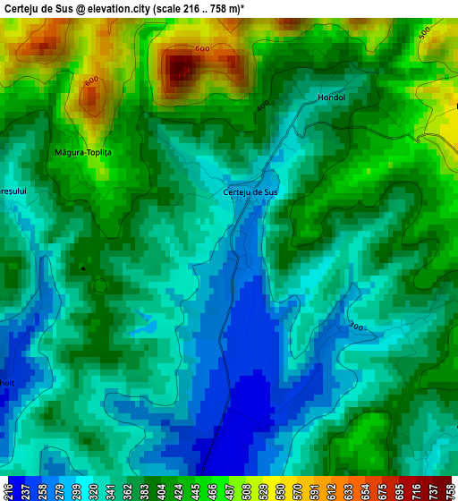
Below is the Elevation map of Certeju de Sus, which displays elevation range with different colors. Scale of the first map is from 216 to 758 m (709 to 2487 ft) with average elevation of 377.2 meters (=1238 ft) [note 1]
These maps also provides idea of topography and contour of this city, they are displayed at different zoom levels. More info about maps, scale and edge coordinates you can find below images.
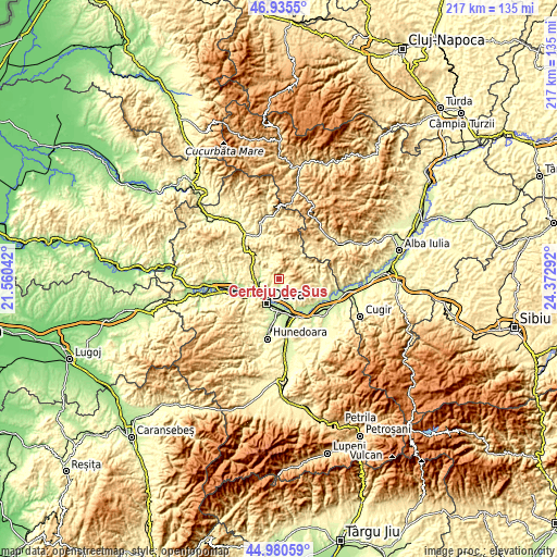
| \ | Map #1 | Topo.Map |
| Scale [m] | 216..758 m | × |
| Scale [ft] | 709..2487 ft | × |
| Average | 377.2 m = 1238 ft | × |
| Width | 6.79 km = 4.2 mi | 217.4 km = 135.1 mi |
| Height | 6.79 km = 4.2 mi | 217.4 km = 135.1 mi |
| ↑Max Latitude | 45.997207° | 46.9355° |
| Latitude at center | 45.96667° | 45.96667° |
| ↓Min Latitude | 45.936116° | 44.98059° |
| ← Min Longitude | 22.922725° | 21.56042° |
| Longitude center | 22.96667° | 22.96667° |
| →Max Longitude | 23.010615° | 24.37292° |
Nearby cities:
Cities around Certeju de Sus sort by population:
• Deva elevation 196 m
10.6 km,  209°
209°
• Simeria 200 m
13.5 km,  163°
163°
• Băiţa 280 m
9 km,  325°
325°
• Şoimuş 194 m
7.6 km,  222°
222°
• Veţel 211 m
13.8 km,  237°
237°
• Hărău 182 m
7.5 km,  189°
189°
• Rapoltu Mare 217 m
13.5 km,  145°
145°
• Brănişca 204 m
15.2 km,  248°
248°
• Cristur 202 m
15.4 km, 186°
• Vălişoara 384 m
12.9 km,  315°
315°
• Balşa 526 m
13.8 km,  57°
57°
• Hărțăgani 305 m
9.9 km,  339°
339°
Multilingual:
 En español:
Certeju de Sus elevación 279 m.
 En France:
Certeju de Sus élévation 279 m.
 Auf Deutsch:
Certeju de Sus höhe über dem Meeresspiegel ist 279 m.

Sources and notes:
- [note 1] Map square and city borders are not equal. Map elevation data is calculated only from area inside that square.
- [src 1] Elevation data from geonames database provided with same terms of usage.
- [src 2] The elevation map of Certeju de Sus is generated using elevation data from NASA's 3 arcsec (90m) resolution SRTM data.
- [src 3] Base (background) map © OpenStreetMap contributors tiles are generated by Geofabrik and OpenTopoMap.
Copyright & License:
This Certeju de Sus Elevation Map is licensed under CC BY-SA. You may reuse any part from this page, if you give a proper credit by linking to this URL:
 More info on terms of use page.