Simeria elevation
Simeria (Hunedoara, Oraş Simeria), Romania elevation is 200 meters and Simeria elevation in feet is 656 ft above sea level [src 1]. Simeria is a seat of a second-order administrative division (feature code) with elevation that is 52 meters (171 ft) smaller than average city elevation in Romania.
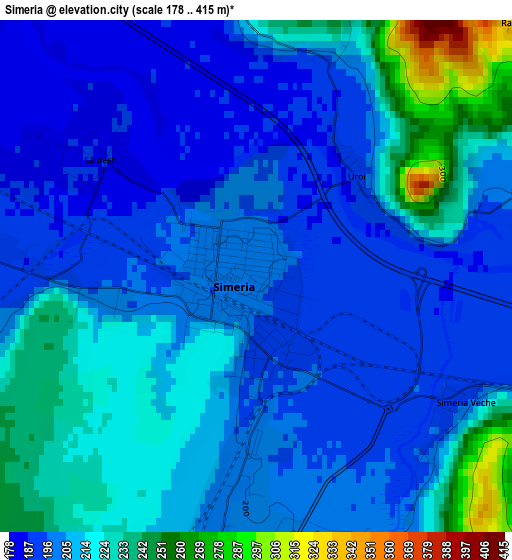
Below is the Elevation map of Simeria, which displays elevation range with different colors. Scale of the first map is from 178 to 415 m (584 to 1362 ft) with average elevation of 210.1 meters (=689 ft) [note 1]
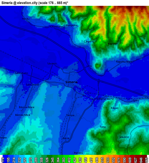
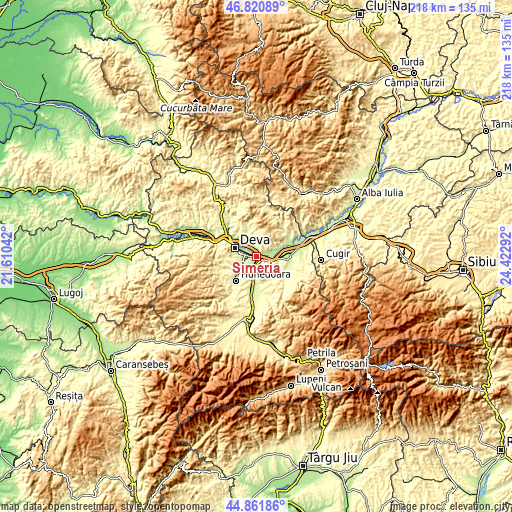
These maps also provides idea of topography and contour of this city, they are displayed at different zoom levels. More info about maps, scale and edge coordinates you can find below images.
| \ | Map #1 | Map #2 | Topo.Map |
| Scale [m] | 178..415 m | 176..665 m | × |
| Scale [ft] | 584..1362 ft | 577..2182 ft | × |
| Average | 210.1 m = 689 ft | 255.8 m = 839 ft | × |
| Width | 6.81 km = 4.2 mi | 13.61 km = 8.5 mi | 217.8 km = 135.3 mi |
| Height | 6.81 km = 4.2 mi | 13.61 km = 8.5 mi | 217.8 km = 135.3 mi |
| ↑Max Latitude | 45.880601° | 45.911186° | 46.82089° |
| Latitude at center | 45.85° | 45.85° | 45.85° |
| ↓Min Latitude | 45.819382° | 45.788747° | 44.86186° |
| ← Min Longitude | 22.972725° | 22.928779° | 21.61042° |
| Longitude center | 23.01667° | 23.01667° | 23.01667° |
| →Max Longitude | 23.060615° | 23.104561° | 24.42292° |
Nearby cities:
Cities around Simeria sort by population:
• Deva elevation 196 m
9.8 km,  292°
292°
• Călan 245 m
13.2 km,  191°
191°
• Şoimuş 194 m
11.7 km,  309°
309°
• Hărău 182 m
7.6 km,  317°
317°
• Rapoltu Mare 217 m
4.3 km,  64°
64°
• Turdaş 195 m
7.7 km,  90°
90°
• Băcia 206 m
5.6 km,  180°
180°
• Cristur 202 m
6.1 km,  248°
248°
• Peștișu Mare 209 m
8.8 km,  232°
232°
• Peştişu Mic 245 m
11.7 km,  241°
241°
• Pricaz 207 m
12.1 km, 85°
• Mărtineşti 222 m
9.8 km,  112°
112°
Multilingual:
 En español:
Simeria elevación 200 m.
 En France:
Simeria élévation 200 m.


Sources and notes:
- [note 1] Map square and city borders are not equal. Map elevation data is calculated only from area inside that square.
- [src 1] Elevation data from geonames database provided with same terms of usage.
- [src 2] The elevation map of Simeria is generated using elevation data from NASA's 3 arcsec (90m) resolution SRTM data.
- [src 3] Base (background) map © OpenStreetMap contributors tiles are generated by Geofabrik and OpenTopoMap.
Copyright & License:
This Simeria Elevation Map is licensed under CC BY-SA. You may reuse any part from this page, if you give a proper credit by linking to this URL:
 More info on terms of use page.