Chiojdeanca elevation
Chiojdeanca (Prahova, Comuna Chiojdeanca), Romania elevation is 359 meters and Chiojdeanca elevation in feet is 1178 ft above sea level [src 1]. Chiojdeanca is a seat of a second-order administrative division (feature code) with elevation that is 107 meters (351 ft) bigger than average city elevation in Romania.
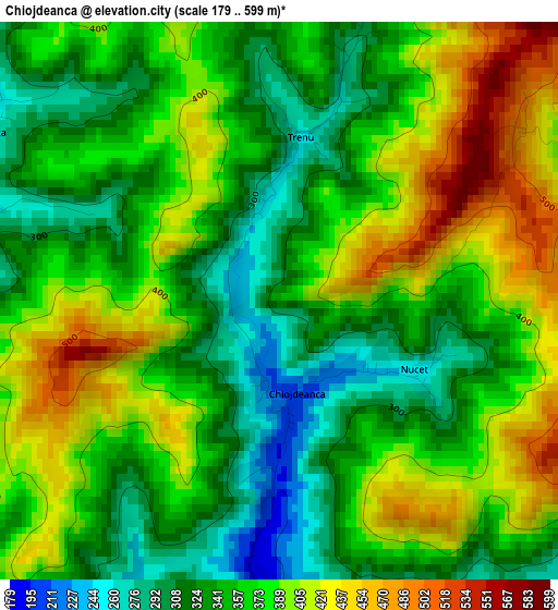
Below is the Elevation map of Chiojdeanca, which displays elevation range with different colors. Scale of the first map is from 179 to 599 m (587 to 1965 ft) with average elevation of 365.9 meters (=1200 ft) [note 1]
These maps also provides idea of topography and contour of this city, they are displayed at different zoom levels. More info about maps, scale and edge coordinates you can find below images.
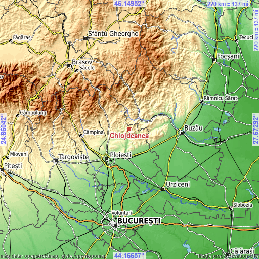
| \ | Map #1 | Topo.Map |
| Scale [m] | 179..599 m | × |
| Scale [ft] | 587..1965 ft | × |
| Average | 365.9 m = 1200 ft | × |
| Width | 6.89 km = 4.3 mi | 220.5 km = 137 mi |
| Height | 6.89 km = 4.3 mi | 220.5 km = 137 mi |
| ↑Max Latitude | 45.197645° | 46.14952° |
| Latitude at center | 45.16667° | 45.16667° |
| ↓Min Latitude | 45.135678° | 44.16657° |
| ← Min Longitude | 26.222725° | 24.86042° |
| Longitude center | 26.26667° | 26.26667° |
| →Max Longitude | 26.310615° | 27.67292° |
Nearby cities:
Cities around Chiojdeanca sort by population:
• Sângeru elevation 260 m
7.5 km,  119°
119°
• Calvini 324 m
9.6 km,  15°
15°
• Şoimari 234 m
5.5 km,  289°
289°
• Gornet-Cricov 241 m
9.3 km,  180°
180°
• Apostolache 193 m
3.7 km, 180°
• Cărbuneşti 337 m
9.1 km,  324°
324°
• Surani 362 m
8.7 km,  295°
295°
• Mireșu Mare 238 m
9.3 km,  112°
112°
• Tătaru 420 m
9.1 km,  144°
144°
• Salcia 386 m
5.5 km,  70°
70°
• Valea Dulce 178 m
7.4 km,  218°
218°
• Ariceștii Zeletin 294 m
9.2 km,  312°
312°
Multilingual:
 En español:
Chiojdeanca elevación 359 m.
 En France:
Chiojdeanca élévation 359 m.
 Auf Deutsch:
Chiojdeanca höhe über dem Meeresspiegel ist 359 m.

Sources and notes:
- [note 1] Map square and city borders are not equal. Map elevation data is calculated only from area inside that square.
- [src 1] Elevation data from geonames database provided with same terms of usage.
- [src 2] The elevation map of Chiojdeanca is generated using elevation data from NASA's 3 arcsec (90m) resolution SRTM data.
- [src 3] Base (background) map © OpenStreetMap contributors tiles are generated by Geofabrik and OpenTopoMap.
Copyright & License:
This Chiojdeanca Elevation Map is licensed under CC BY-SA. You may reuse any part from this page, if you give a proper credit by linking to this URL:
 More info on terms of use page.