Sângeru elevation
Sângeru (Prahova, Comuna Sângeru), Romania elevation is 260 meters and Sângeru elevation in feet is 853 ft above sea level [src 1]. Sângeru is a seat of a second-order administrative division (feature code) with elevation that is 8 meters (26 ft) bigger than average city elevation in Romania.
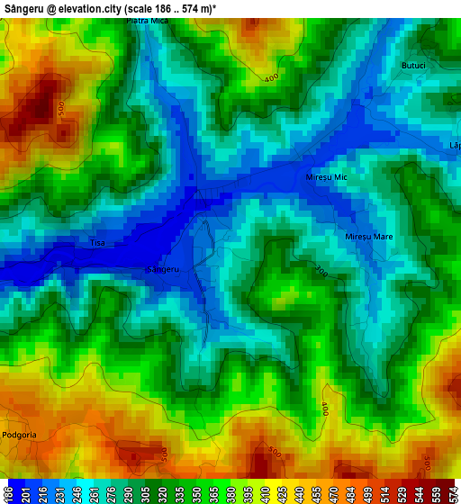
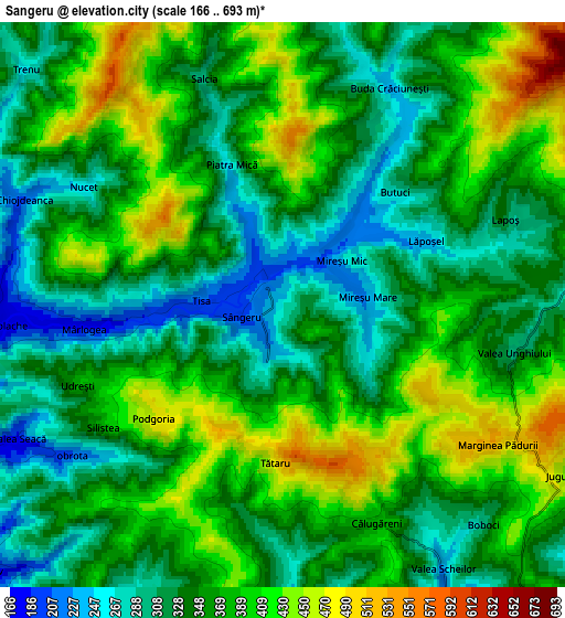
Below is the Elevation map of Sângeru, which displays elevation range with different colors. Scale of the first map is from 186 to 574 m (610 to 1883 ft) with average elevation of 328.9 meters (=1079 ft) [note 1]
These maps also provides idea of topography and contour of this city, they are displayed at different zoom levels. More info about maps, scale and edge coordinates you can find below images.
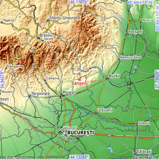
| \ | Map #1 | Map #2 | Topo.Map |
| Scale [m] | 186..574 m | 166..693 m | × |
| Scale [ft] | 610..1883 ft | 545..2274 ft | × |
| Average | 328.9 m = 1079 ft | 357.8 m = 1174 ft | × |
| Width | 6.89 km = 4.3 mi | 13.79 km = 8.6 mi | 220.6 km = 137.1 mi |
| Height | 6.89 km = 4.3 mi | 13.79 km = 8.6 mi | 220.6 km = 137.1 mi |
| ↑Max Latitude | 45.164323° | 45.1953° | 46.11676° |
| Latitude at center | 45.13333° | 45.13333° | 45.13333° |
| ↓Min Latitude | 45.10232° | 45.071293° | 44.13265° |
| ← Min Longitude | 26.306055° | 26.262109° | 24.94375° |
| Longitude center | 26.35° | 26.35° | 26.35° |
| →Max Longitude | 26.393945° | 26.437891° | 27.75625° |
Nearby cities:
Cities around Sângeru sort by population:
• Gornet-Cricov elevation 241 m
8.6 km,  229°
229°
• Apostolache 193 m
6.5 km,  270°
270°
• Năeni 345 m
11.1 km,  109°
109°
• Chiojdeanca 359 m
7.5 km,  299°
299°
• Mireșu Mare 238 m
2.1 km,  84°
84°
• Călugăreni 373 m
6.1 km,  154°
154°
• Tătaru 420 m
3.9 km,  199°
199°
• Salcia 386 m
5.7 km,  346°
346°
• Valea Dulce 178 m
11.3 km,  259°
259°
• Lapoș 328 m
5.8 km,  69°
69°
• Vadu Săpat 169 m
10.8 km,  164°
164°
• Jugureni 451 m
8.7 km,  115°
115°
Multilingual:
 En español:
Sângeru elevación 260 m.
 En France:
Sângeru élévation 260 m.


Sources and notes:
- [note 1] Map square and city borders are not equal. Map elevation data is calculated only from area inside that square.
- [src 1] Elevation data from geonames database provided with same terms of usage.
- [src 2] The elevation map of Sângeru is generated using elevation data from NASA's 3 arcsec (90m) resolution SRTM data.
- [src 3] Base (background) map © OpenStreetMap contributors tiles are generated by Geofabrik and OpenTopoMap.
Copyright & License:
This Sângeru Elevation Map is licensed under CC BY-SA. You may reuse any part from this page, if you give a proper credit by linking to this URL:
 More info on terms of use page.