Cidreag elevation
Cidreag (Satu Mare, Comuna Porumbeşti), Romania elevation is 122 meters and Cidreag elevation in feet is 400 ft above sea level [src 1]. Cidreag is a populated place (feature code) with elevation that is 130 meters (427 ft) smaller than average city elevation in Romania.
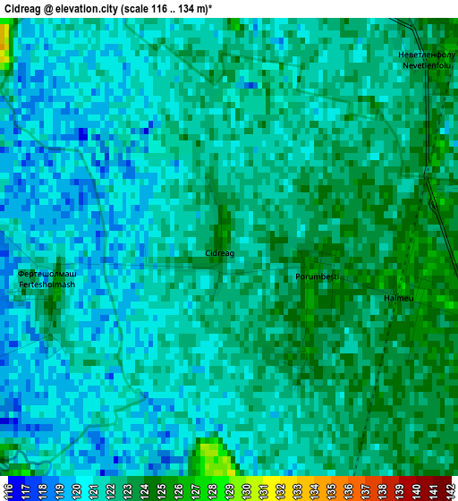
Below is the Elevation map of Cidreag, which displays elevation range with different colors. Scale of the first map is from 116 to 134 m (381 to 440 ft) with average elevation of 121.4 meters (=398 ft) [note 1]
These maps also provides idea of topography and contour of this city, they are displayed at different zoom levels. More info about maps, scale and edge coordinates you can find below images.
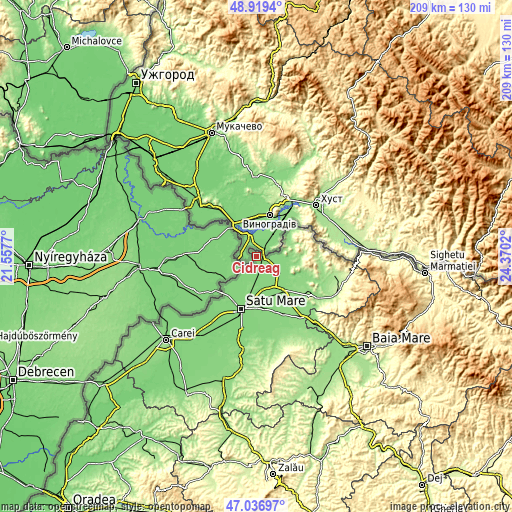
| \ | Map #1 | Topo.Map |
| Scale [m] | 116..134 m | × |
| Scale [ft] | 381..440 ft | × |
| Average | 121.4 m = 398 ft | × |
| Width | 6.54 km = 4.1 mi | 209.3 km = 130.1 mi |
| Height | 6.54 km = 4.1 mi | 209.3 km = 130.1 mi |
| ↑Max Latitude | 48.016174° | 48.9194° |
| Latitude at center | 47.98677° | 47.98677° |
| ↓Min Latitude | 47.957349° | 47.03697° |
| ← Min Longitude | 22.920005° | 21.5577° |
| Longitude center | 22.96395° | 22.96395° |
| →Max Longitude | 23.007895° | 24.3702° |
Nearby cities:
Cities around Cidreag sort by population:
• Halmeu elevation 123 m
4.5 km,  119°
119°
• Lazuri 123 m
16.8 km,  205°
205°
• Botiz 128 m
17.1 km,  183°
183°
• Turulung 132 m
10.7 km, 123°
• Micula 125 m
9.7 km,  186°
186°
• Bătarci 151 m
15.9 km,  71°
71°
• Gherța Mare 168 m
18.3 km,  96°
96°
• Porumbești 125 m
1.3 km,  108°
108°
• Valea Seacă 150 m
18.2 km,  55°
55°
• Drăgușeni 129 m
12.4 km,  136°
136°
• Agriș 127 m
12.1 km,  166°
166°
• Dumbrava 131 m
18.1 km,  151°
151°
Multilingual:
 En español:
Cidreag elevación 122 m.
 En France:
Cidreag élévation 122 m.


Sources and notes:
- [note 1] Map square and city borders are not equal. Map elevation data is calculated only from area inside that square.
- [src 1] Elevation data from geonames database provided with same terms of usage.
- [src 2] The elevation map of Cidreag is generated using elevation data from NASA's 3 arcsec (90m) resolution SRTM data.
- [src 3] Base (background) map © OpenStreetMap contributors tiles are generated by Geofabrik and OpenTopoMap.
Copyright & License:
This Cidreag Elevation Map is licensed under CC BY-SA. You may reuse any part from this page, if you give a proper credit by linking to this URL:
 More info on terms of use page.