Gherța Mare elevation
Gherța Mare (Satu Mare, Comuna Turţ), Romania elevation is 168 meters and Gherța Mare elevation in feet is 551 ft above sea level [src 1]. Gherța Mare is a populated place (feature code) with elevation that is 84 meters (276 ft) smaller than average city elevation in Romania.
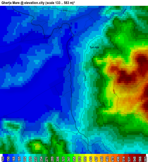
Below is the Elevation map of Gherța Mare, which displays elevation range with different colors. Scale of the first map is from 133 to 583 m (436 to 1913 ft) with average elevation of 232.6 meters (=763 ft) [note 1]
These maps also provides idea of topography and contour of this city, they are displayed at different zoom levels. More info about maps, scale and edge coordinates you can find below images.
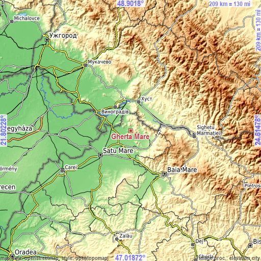
| \ | Map #1 | Topo.Map |
| Scale [m] | 133..583 m | × |
| Scale [ft] | 436..1913 ft | × |
| Average | 232.6 m = 763 ft | × |
| Width | 6.54 km = 4.1 mi | 209.4 km = 130.1 mi |
| Height | 6.54 km = 4.1 mi | 209.4 km = 130.1 mi |
| ↑Max Latitude | 47.998255° | 48.9018° |
| Latitude at center | 47.96884° | 47.96884° |
| ↓Min Latitude | 47.939409° | 47.01872° |
| ← Min Longitude | 23.164585° | 21.80228° |
| Longitude center | 23.20853° | 23.20853° |
| →Max Longitude | 23.252475° | 24.61478° |
Nearby cities:
Cities around Gherța Mare sort by population:
• Livada elevation 132 m
12.7 km,  206°
206°
• Turţ 204 m
1.7 km,  20°
20°
• Călineşti-Oaş 143 m
10.2 km,  138°
138°
• Turulung 132 m
10.1 km,  247°
247°
• Bătarci 151 m
7.8 km,  336°
336°
• Gherţa Mică 172 m
4.4 km,  154°
154°
• Târşolţel 235 m
10.7 km,  101°
101°
• Cămărzana 219 m
8.8 km,  66°
66°
• Boinești 171 m
12.2 km,  119°
119°
• Valea Seacă 150 m
12.9 km,  345°
345°
• Drăgușeni 129 m
12 km,  234°
234°
• Târşolţ 235 m
10.7 km, 101°
Multilingual:
 En español:
Gherța Mare elevación 168 m.
 En France:
Gherța Mare élévation 168 m.
 Auf Deutsch:
Gherța Mare höhe über dem Meeresspiegel ist 168 m.

Sources and notes:
- [note 1] Map square and city borders are not equal. Map elevation data is calculated only from area inside that square.
- [src 1] Elevation data from geonames database provided with same terms of usage.
- [src 2] The elevation map of Gherța Mare is generated using elevation data from NASA's 3 arcsec (90m) resolution SRTM data.
- [src 3] Base (background) map © OpenStreetMap contributors tiles are generated by Geofabrik and OpenTopoMap.
Copyright & License:
This Gherța Mare Elevation Map is licensed under CC BY-SA. You may reuse any part from this page, if you give a proper credit by linking to this URL:
 More info on terms of use page.