Copăcele elevation
Copăcele (Caraş-Severin, Comuna Copăcele), Romania elevation is 214 meters and Copăcele elevation in feet is 702 ft above sea level [src 1]. Copăcele is a seat of a second-order administrative division (feature code) with elevation that is 38 meters (125 ft) smaller than average city elevation in Romania.
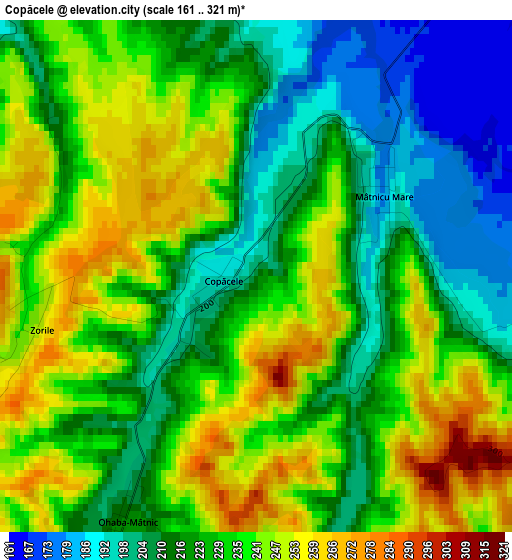
Below is the Elevation map of Copăcele, which displays elevation range with different colors. Scale of the first map is from 161 to 321 m (528 to 1053 ft) with average elevation of 228.4 meters (=749 ft) [note 1]
These maps also provides idea of topography and contour of this city, they are displayed at different zoom levels. More info about maps, scale and edge coordinates you can find below images.
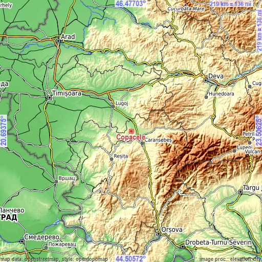
| \ | Map #1 | Topo.Map |
| Scale [m] | 161..321 m | × |
| Scale [ft] | 528..1053 ft | × |
| Average | 228.4 m = 749 ft | × |
| Width | 6.85 km = 4.3 mi | 219.2 km = 136.2 mi |
| Height | 6.85 km = 4.3 mi | 219.2 km = 136.2 mi |
| ↑Max Latitude | 45.530793° | 46.47703° |
| Latitude at center | 45.5° | 45.5° |
| ↓Min Latitude | 45.46919° | 44.50572° |
| ← Min Longitude | 22.056055° | 20.69375° |
| Longitude center | 22.1° | 22.1° |
| →Max Longitude | 22.143945° | 23.50625° |
Nearby cities:
Cities around Copăcele sort by population:
• Caransebeş elevation 202 m
13 km,  135°
135°
• Obreja 200 m
11.8 km,  99°
99°
• Gavojdia 142 m
14.5 km,  333°
333°
• Constantin Daicoviciu 160 m
6.8 km,  35°
35°
• Păltiniş 268 m
8.4 km,  152°
152°
• Glimboca 284 m
17 km, 96°
• Ştiuca 183 m
12.5 km,  309°
309°
• Criciova 164 m
15.1 km,  350°
350°
• Sacu 153 m
7.5 km,  9°
9°
• Brebu 210 m
12.2 km,  223°
223°
• Zorlenţu Mare 192 m
12.5 km,  243°
243°
• Cornuțel 262 m
7.2 km,  182°
182°
Multilingual:
 En español:
Copăcele elevación 214 m.
 En France:
Copăcele élévation 214 m.
 Auf Deutsch:
Copăcele höhe über dem Meeresspiegel ist 214 m.

Sources and notes:
- [note 1] Map square and city borders are not equal. Map elevation data is calculated only from area inside that square.
- [src 1] Elevation data from geonames database provided with same terms of usage.
- [src 2] The elevation map of Copăcele is generated using elevation data from NASA's 3 arcsec (90m) resolution SRTM data.
- [src 3] Base (background) map © OpenStreetMap contributors tiles are generated by Geofabrik and OpenTopoMap.
Copyright & License:
This Copăcele Elevation Map is licensed under CC BY-SA. You may reuse any part from this page, if you give a proper credit by linking to this URL:
 More info on terms of use page.