Gavojdia elevation
Gavojdia (Timiş, Comuna Gavojdia), Romania elevation is 142 meters and Gavojdia elevation in feet is 466 ft above sea level [src 1]. Gavojdia is a seat of a second-order administrative division (feature code) with elevation that is 110 meters (361 ft) smaller than average city elevation in Romania.
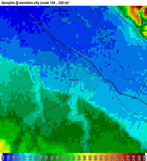
Below is the Elevation map of Gavojdia, which displays elevation range with different colors. Scale of the first map is from 128 to 226 m (420 to 741 ft) with average elevation of 146.2 meters (=480 ft) [note 1]
These maps also provides idea of topography and contour of this city, they are displayed at different zoom levels. More info about maps, scale and edge coordinates you can find below images.
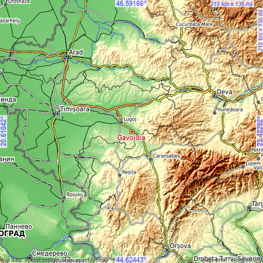
| \ | Map #1 | Topo.Map |
| Scale [m] | 128..226 m | × |
| Scale [ft] | 420..741 ft | × |
| Average | 146.2 m = 480 ft | × |
| Width | 6.84 km = 4.3 mi | 218.7 km = 135.9 mi |
| Height | 6.84 km = 4.3 mi | 218.7 km = 135.9 mi |
| ↑Max Latitude | 45.647399° | 46.59166° |
| Latitude at center | 45.61667° | 45.61667° |
| ↓Min Latitude | 45.585924° | 44.62443° |
| ← Min Longitude | 21.972725° | 20.61042° |
| Longitude center | 22.01667° | 22.01667° |
| →Max Longitude | 22.060615° | 23.42292° |
Nearby cities:
Cities around Gavojdia sort by population:
• Lugoj elevation 122 m
11.9 km,  312°
312°
• Coşteiu 114 m
19 km,  316°
316°
• Nădrag 278 m
13.5 km,  74°
74°
• Victor Vlad Delamarina 139 m
10 km,  285°
285°
• Constantin Daicoviciu 160 m
12.8 km,  125°
125°
• Fârdea 259 m
17.4 km,  41°
41°
• Ştiuca 183 m
5.9 km,  211°
211°
• Criciova 164 m
4.3 km,  64°
64°
• Sacu 153 m
9.6 km, 125°
• Bârna 213 m
11.4 km,  13°
13°
• Copăcele 214 m
14.5 km,  153°
153°
• Zorlenţu Mare 192 m
19.1 km,  194°
194°
Multilingual:
 En español:
Gavojdia elevación 142 m.
 En France:
Gavojdia élévation 142 m.
 Auf Deutsch:
Gavojdia höhe über dem Meeresspiegel ist 142 m.

Sources and notes:
- [note 1] Map square and city borders are not equal. Map elevation data is calculated only from area inside that square.
- [src 1] Elevation data from geonames database provided with same terms of usage.
- [src 2] The elevation map of Gavojdia is generated using elevation data from NASA's 3 arcsec (90m) resolution SRTM data.
- [src 3] Base (background) map © OpenStreetMap contributors tiles are generated by Geofabrik and OpenTopoMap.
Copyright & License:
This Gavojdia Elevation Map is licensed under CC BY-SA. You may reuse any part from this page, if you give a proper credit by linking to this URL:
 More info on terms of use page.