Obreja elevation
Obreja (Caraş-Severin, Comuna Obreja), Romania elevation is 200 meters and Obreja elevation in feet is 656 ft above sea level [src 1]. Obreja is a seat of a second-order administrative division (feature code) with elevation that is 52 meters (171 ft) smaller than average city elevation in Romania.
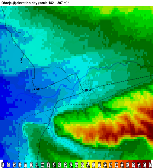
Below is the Elevation map of Obreja, which displays elevation range with different colors. Scale of the first map is from 182 to 307 m (597 to 1007 ft) with average elevation of 218.6 meters (=717 ft) [note 1]
These maps also provides idea of topography and contour of this city, they are displayed at different zoom levels. More info about maps, scale and edge coordinates you can find below images.
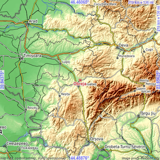
| \ | Map #1 | Topo.Map |
| Scale [m] | 182..307 m | × |
| Scale [ft] | 597..1007 ft | × |
| Average | 218.6 m = 717 ft | × |
| Width | 6.85 km = 4.3 mi | 219.3 km = 136.3 mi |
| Height | 6.85 km = 4.3 mi | 219.2 km = 136.2 mi |
| ↑Max Latitude | 45.514132° | 46.46065° |
| Latitude at center | 45.48333° | 45.48333° |
| ↓Min Latitude | 45.452511° | 44.48876° |
| ← Min Longitude | 22.206055° | 20.84375° |
| Longitude center | 22.25° | 22.25° |
| →Max Longitude | 22.293945° | 23.65625° |
Nearby cities:
Cities around Obreja sort by population:
• Caransebeş elevation 202 m
7.9 km,  199°
199°
• Oţelu Roşu 327 m
10.7 km,  58°
58°
• Zăvoi 318 m
13.5 km,  74°
74°
• Muntele Mic 316 m
12.9 km,  149°
149°
• Constantin Daicoviciu 160 m
10.8 km,  313°
313°
• Păltiniş 268 m
9.6 km,  234°
234°
• Buchin 224 m
13 km,  180°
180°
• Glimboca 284 m
5.2 km,  90°
90°
• Sacu 153 m
13.9 km, 311°
• Turnu Ruieni 303 m
12.3 km, 147°
• Copăcele 214 m
11.8 km,  279°
279°
• Cornuțel 262 m
13.2 km,  245°
245°
Multilingual:
 En español:
Obreja elevación 200 m.
 En France:
Obreja élévation 200 m.


Sources and notes:
- [note 1] Map square and city borders are not equal. Map elevation data is calculated only from area inside that square.
- [src 1] Elevation data from geonames database provided with same terms of usage.
- [src 2] The elevation map of Obreja is generated using elevation data from NASA's 3 arcsec (90m) resolution SRTM data.
- [src 3] Base (background) map © OpenStreetMap contributors tiles are generated by Geofabrik and OpenTopoMap.
Copyright & License:
This Obreja Elevation Map is licensed under CC BY-SA. You may reuse any part from this page, if you give a proper credit by linking to this URL:
 More info on terms of use page.