Muntele Mic elevation
Muntele Mic (Caraş-Severin, Comuna Turnu Rueni), Romania elevation is 316 meters and Muntele Mic elevation in feet is 1037 ft above sea level [src 1]. Muntele Mic is a populated place (feature code) with elevation that is 64 meters (210 ft) bigger than average city elevation in Romania.
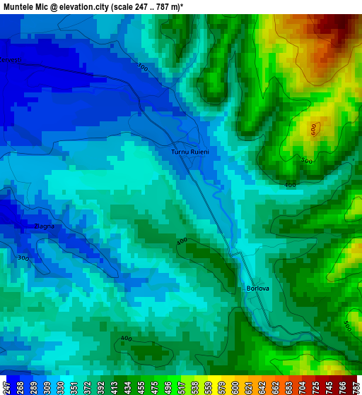
Below is the Elevation map of Muntele Mic, which displays elevation range with different colors. Scale of the first map is from 247 to 787 m (810 to 2582 ft) with average elevation of 379.8 meters (=1246 ft) [note 1]
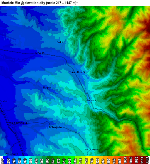
These maps also provides idea of topography and contour of this city, they are displayed at different zoom levels. More info about maps, scale and edge coordinates you can find below images.
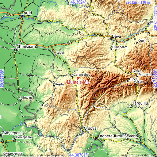
| \ | Map #1 | Map #2 | Topo.Map |
| Scale [m] | 247..787 m | 217..1147 m | × |
| Scale [ft] | 810..2582 ft | 712..3763 ft | × |
| Average | 379.8 m = 1246 ft | 451.6 m = 1482 ft | × |
| Width | 6.86 km = 4.3 mi | 13.73 km = 8.5 mi | 219.6 km = 136.5 mi |
| Height | 6.86 km = 4.3 mi | 13.73 km = 8.5 mi | 219.6 km = 136.5 mi |
| ↑Max Latitude | 45.414187° | 45.445027° | 46.3624° |
| Latitude at center | 45.38333° | 45.38333° | 45.38333° |
| ↓Min Latitude | 45.352456° | 45.321565° | 44.38701° |
| ← Min Longitude | 22.289385° | 22.245439° | 20.92708° |
| Longitude center | 22.33333° | 22.33333° | 22.33333° |
| →Max Longitude | 22.377275° | 22.421221° | 23.73958° |
Nearby cities:
Cities around Muntele Mic sort by population:
• Caransebeş elevation 202 m
9.8 km,  292°
292°
• Obreja 200 m
12.9 km,  329°
329°
• Slatina-Timiş 338 m
15.3 km,  194°
194°
• Bucoşniţa 283 m
10.6 km,  209°
209°
• Buchin 224 m
6.8 km,  254°
254°
• Glimboca 284 m
11.2 km,  353°
353°
• Turnu Ruieni 303 m
0.8 km,  12°
12°
• Borlova 358 m
2.3 km,  140°
140°
• Vârciorova 381 m
6.4 km,  166°
166°
• Petroșnița 254 m
8.8 km,  221°
221°
• Măru 404 m
13.8 km,  41°
41°
• Bolvașnița 293 m
4.6 km,  203°
203°
Multilingual:
 En español:
Muntele Mic elevación 316 m.
 En France:
Muntele Mic élévation 316 m.
 Auf Deutsch:
Muntele Mic höhe über dem Meeresspiegel ist 316 m.

Sources and notes:
- [note 1] Map square and city borders are not equal. Map elevation data is calculated only from area inside that square.
- [src 1] Elevation data from geonames database provided with same terms of usage.
- [src 2] The elevation map of Muntele Mic is generated using elevation data from NASA's 3 arcsec (90m) resolution SRTM data.
- [src 3] Base (background) map © OpenStreetMap contributors tiles are generated by Geofabrik and OpenTopoMap.
Copyright & License:
This Muntele Mic Elevation Map is licensed under CC BY-SA. You may reuse any part from this page, if you give a proper credit by linking to this URL:
 More info on terms of use page.