Corabia elevation
Corabia (Olt, Oraş Corabia), Romania elevation is 54 meters and Corabia elevation in feet is 177 ft above sea level [src 1]. Corabia is a seat of a second-order administrative division (feature code) with elevation that is 198 meters (650 ft) smaller than average city elevation in Romania.
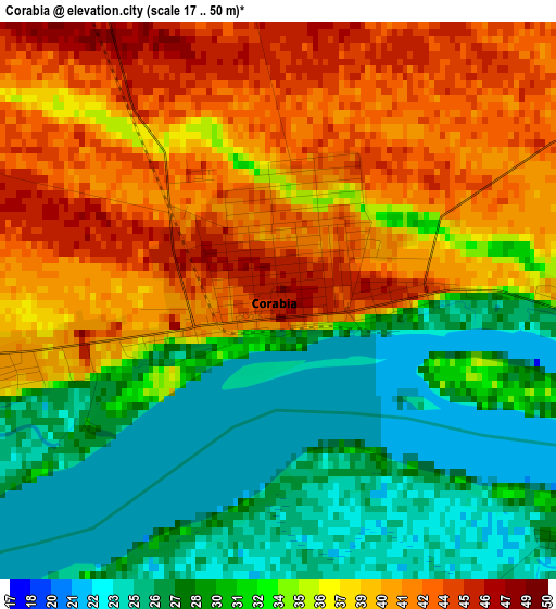
Below is the Elevation map of Corabia, which displays elevation range with different colors. Scale of the first map is from 17 to 50 m (56 to 164 ft) with average elevation of 34.7 meters (=114 ft) [note 1]
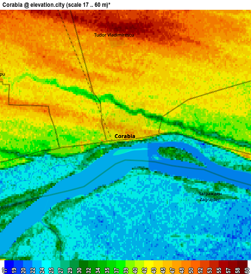
These maps also provides idea of topography and contour of this city, they are displayed at different zoom levels. More info about maps, scale and edge coordinates you can find below images.
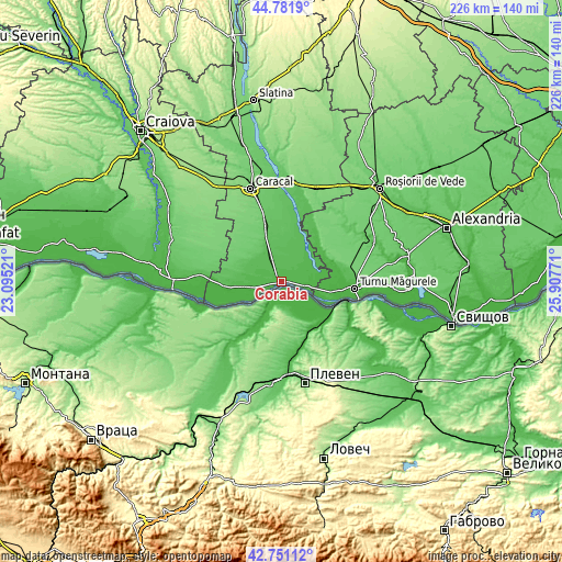
| \ | Map #1 | Map #2 | Topo.Map |
| Scale [m] | 17..50 m | 17..60 m | × |
| Scale [ft] | 56..164 ft | 56..197 ft | × |
| Average | 34.7 m = 114 ft | 35.7 m = 117 ft | × |
| Width | 7.06 km = 4.4 mi | 14.11 km = 8.8 mi | 225.8 km = 140.3 mi |
| Height | 7.06 km = 4.4 mi | 14.11 km = 8.8 mi | 225.8 km = 140.3 mi |
| ↑Max Latitude | 43.806853° | 43.838559° | 44.7819° |
| Latitude at center | 43.77513° | 43.77513° | 43.77513° |
| ↓Min Latitude | 43.74339° | 43.711634° | 42.75112° |
| ← Min Longitude | 24.457515° | 24.413569° | 23.09521° |
| Longitude center | 24.50146° | 24.50146° | 24.50146° |
| →Max Longitude | 24.545405° | 24.589351° | 25.90771° |
Nearby cities:
Cities around Corabia sort by population:
• Izbiceni elevation 40 m
13.6 km,  61°
61°
• Tia Mare 46 m
14.7 km,  46°
46°
• Orlea 27 m
9.9 km,  253°
253°
• Vădastra 67 m
14.9 km,  313°
313°
• Vişina 53 m
11 km,  337°
337°
• Gârcov 33 m
9.4 km,  100°
100°
• Vișina Nouă 55 m
12.9 km,  328°
328°
• Potlogeni 46 m
15.6 km,  41°
41°
• Gura Padinii 35 m
15 km,  262°
262°
• Doanca 41 m
14.4 km, 55°
• Ursa 38 m
11 km,  82°
82°
• Orlea Nouă 43 m
11.7 km, 259°
Multilingual:
 En español:
Corabia elevación 54 m.
 En France:
Corabia élévation 54 m.


Sources and notes:
- [note 1] Map square and city borders are not equal. Map elevation data is calculated only from area inside that square.
- [src 1] Elevation data from geonames database provided with same terms of usage.
- [src 2] The elevation map of Corabia is generated using elevation data from NASA's 3 arcsec (90m) resolution SRTM data.
- [src 3] Base (background) map © OpenStreetMap contributors tiles are generated by Geofabrik and OpenTopoMap.
Copyright & License:
This Corabia Elevation Map is licensed under CC BY-SA. You may reuse any part from this page, if you give a proper credit by linking to this URL:
 More info on terms of use page.