Costişa elevation
Costişa (Neamţ, Comuna Costişa), Romania elevation is 224 meters and Costişa elevation in feet is 735 ft above sea level [src 1]. Costişa is a seat of a second-order administrative division (feature code) with elevation that is 28 meters (92 ft) smaller than average city elevation in Romania.
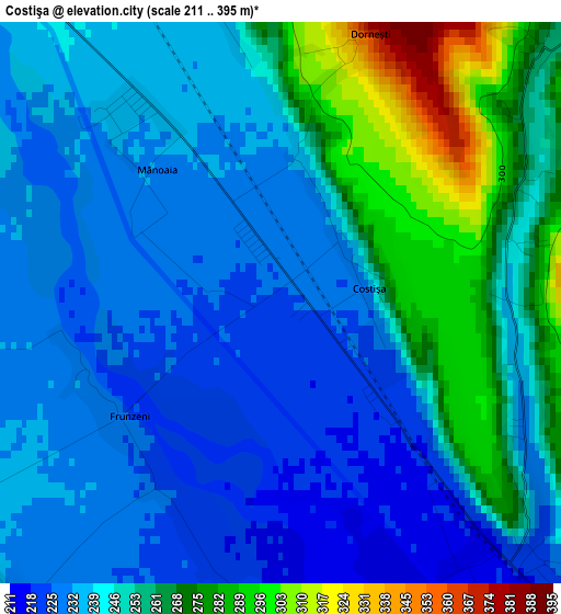
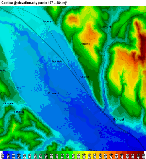
Below is the Elevation map of Costişa, which displays elevation range with different colors. Scale of the first map is from 211 to 395 m (692 to 1296 ft) with average elevation of 247.2 meters (=811 ft) [note 1]
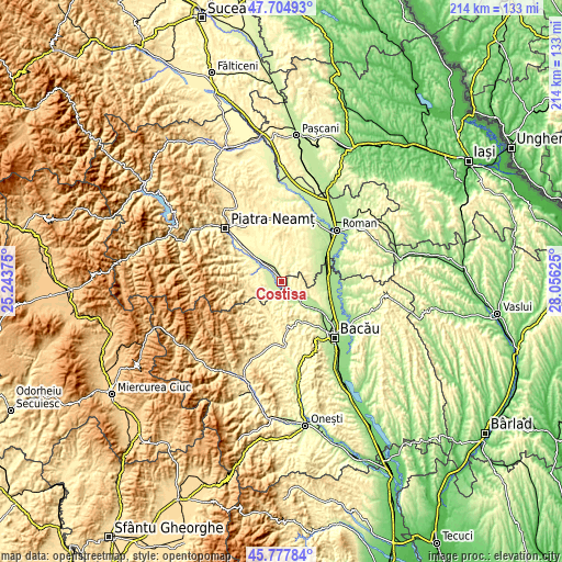
These maps also provides idea of topography and contour of this city, they are displayed at different zoom levels. More info about maps, scale and edge coordinates you can find below images.
| \ | Map #1 | Map #2 | Topo.Map |
| Scale [m] | 211..395 m | 197..484 m | × |
| Scale [ft] | 692..1296 ft | 646..1588 ft | × |
| Average | 247.2 m = 811 ft | 272.2 m = 893 ft | × |
| Width | 6.7 km = 4.2 mi | 13.39 km = 8.3 mi | 214.3 km = 133.2 mi |
| Height | 6.7 km = 4.2 mi | 13.39 km = 8.3 mi | 214.3 km = 133.2 mi |
| ↑Max Latitude | 46.780102° | 46.810188° | 47.70493° |
| Latitude at center | 46.75° | 46.75° | 46.75° |
| ↓Min Latitude | 46.719881° | 46.689745° | 45.77784° |
| ← Min Longitude | 26.606055° | 26.562109° | 25.24375° |
| Longitude center | 26.65° | 26.65° | 26.65° |
| →Max Longitude | 26.693945° | 26.737891° | 28.05625° |
Nearby cities:
Cities around Costişa sort by population:
• Buhuşi elevation 254 m
5.3 km,  134°
134°
• Blăgeşti 329 m
7.4 km,  180°
180°
• Podoleni 247 m
6.1 km,  335°
335°
• Rediu 276 m
6.7 km,  275°
275°
• Români 344 m
4.5 km,  34°
34°
• Bărcăneşti 259 m
6.3 km,  233°
233°
• Racova 238 m
9.4 km, 126°
• Siliștea 257 m
4.5 km,  46°
46°
• Valea lui Ion 268 m
5.5 km,  200°
200°
• Poloboc 293 m
7.7 km, 279°
• Vădurele 250 m
6.4 km,  249°
249°
• Cândeşti 259 m
6.3 km, 233°
Multilingual:
 En español:
Costişa elevación 224 m.
 En France:
Costişa élévation 224 m.


Sources and notes:
- [note 1] Map square and city borders are not equal. Map elevation data is calculated only from area inside that square.
- [src 1] Elevation data from geonames database provided with same terms of usage.
- [src 2] The elevation map of Costişa is generated using elevation data from NASA's 3 arcsec (90m) resolution SRTM data.
- [src 3] Base (background) map © OpenStreetMap contributors tiles are generated by Geofabrik and OpenTopoMap.
Copyright & License:
This Costişa Elevation Map is licensed under CC BY-SA. You may reuse any part from this page, if you give a proper credit by linking to this URL:
 More info on terms of use page.