Crăciunei elevation
Crăciunei (Olt, Comuna Radomireşti), Romania elevation is 117 meters and Crăciunei elevation in feet is 384 ft above sea level [src 1]. Crăciunei is a populated place (feature code) with elevation that is 135 meters (443 ft) smaller than average city elevation in Romania.
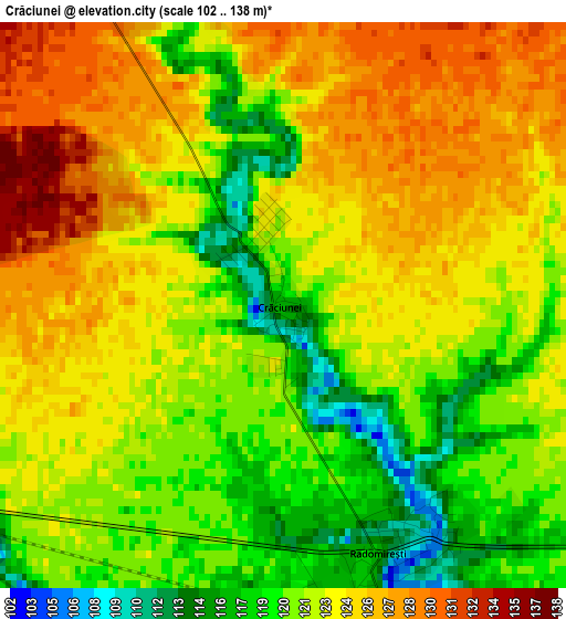
Below is the Elevation map of Crăciunei, which displays elevation range with different colors. Scale of the first map is from 102 to 138 m (335 to 453 ft) with average elevation of 122.5 meters (=402 ft) [note 1]
These maps also provides idea of topography and contour of this city, they are displayed at different zoom levels. More info about maps, scale and edge coordinates you can find below images.
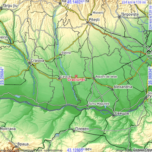
| \ | Map #1 | Topo.Map |
| Scale [m] | 102..138 m | × |
| Scale [ft] | 335..453 ft | × |
| Average | 122.5 m = 402 ft | × |
| Width | 7.01 km = 4.4 mi | 224.4 km = 139.4 mi |
| Height | 7.01 km = 4.4 mi | 224.4 km = 139.4 mi |
| ↑Max Latitude | 44.177275° | 45.14621° |
| Latitude at center | 44.14575° | 44.14575° |
| ↓Min Latitude | 44.114208° | 43.12805° |
| ← Min Longitude | 24.619145° | 23.25684° |
| Longitude center | 24.66309° | 24.66309° |
| →Max Longitude | 24.707035° | 26.06934° |
Nearby cities:
Cities around Crăciunei sort by population:
• Drăgăneşti-Olt elevation 82 m
10.6 km,  282°
282°
• Radomireşti 106 m
3.6 km,  153°
153°
• Dăneasa 133 m
7.7 km,  273°
273°
• Gostavăţu 64 m
12.5 km,  236°
236°
• Stoicăneşti 132 m
4.8 km,  330°
330°
• Stoeneşti 74 m
13.4 km,  256°
256°
• Seaca 121 m
7.3 km,  71°
71°
• Mihăeşti 119 m
9.7 km,  98°
98°
• Slăveni 71 m
12.7 km, 238°
• Călinești 109 m
7.9 km,  165°
165°
• Sprâncenata 121 m
7.3 km,  198°
198°
• Bușca 99 m
11.7 km,  108°
108°
Multilingual:
 En español:
Crăciunei elevación 117 m.
 En France:
Crăciunei élévation 117 m.
 Auf Deutsch:
Crăciunei höhe über dem Meeresspiegel ist 117 m.

Sources and notes:
- [note 1] Map square and city borders are not equal. Map elevation data is calculated only from area inside that square.
- [src 1] Elevation data from geonames database provided with same terms of usage.
- [src 2] The elevation map of Crăciunei is generated using elevation data from NASA's 3 arcsec (90m) resolution SRTM data.
- [src 3] Base (background) map © OpenStreetMap contributors tiles are generated by Geofabrik and OpenTopoMap.
Copyright & License:
This Crăciunei Elevation Map is licensed under CC BY-SA. You may reuse any part from this page, if you give a proper credit by linking to this URL:
 More info on terms of use page.