Drăgăneşti-Olt elevation
Drăgăneşti-Olt (Olt, Oraş Drãgãneşti-Olt), Romania elevation is 82 meters and Drăgăneşti-Olt elevation in feet is 269 ft above sea level [src 1]. Drăgăneşti-Olt is a seat of a second-order administrative division (feature code) with elevation that is 170 meters (558 ft) smaller than average city elevation in Romania.
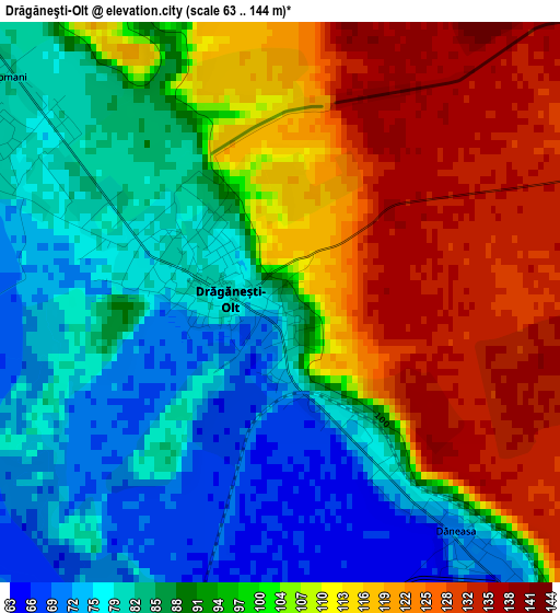
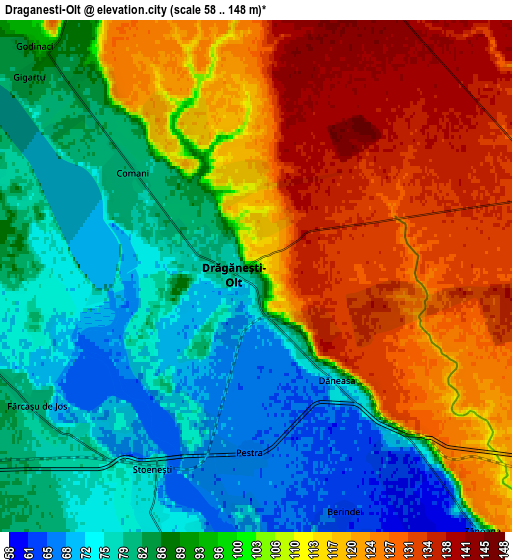
Below is the Elevation map of Drăgăneşti-Olt, which displays elevation range with different colors. Scale of the first map is from 63 to 144 m (207 to 472 ft) with average elevation of 98.5 meters (=323 ft) [note 1]
These maps also provides idea of topography and contour of this city, they are displayed at different zoom levels. More info about maps, scale and edge coordinates you can find below images.
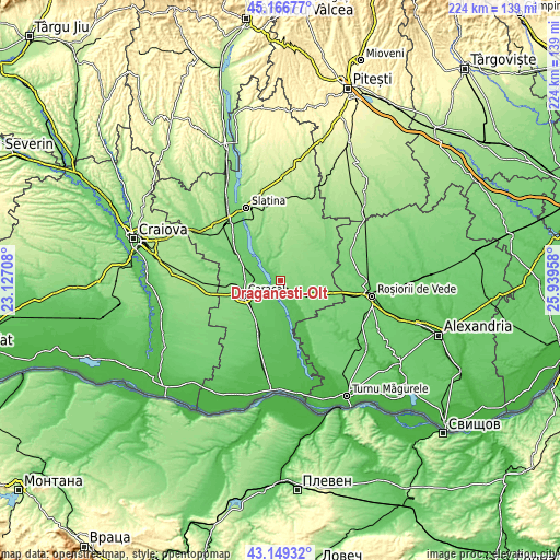
| \ | Map #1 | Map #2 | Topo.Map |
| Scale [m] | 63..144 m | 58..148 m | × |
| Scale [ft] | 207..472 ft | 190..486 ft | × |
| Average | 98.5 m = 323 ft | 100.2 m = 329 ft | × |
| Width | 7.01 km = 4.4 mi | 14.02 km = 8.7 mi | 224.3 km = 139.4 mi |
| Height | 7.01 km = 4.4 mi | 14.02 km = 8.7 mi | 224.3 km = 139.4 mi |
| ↑Max Latitude | 44.198184° | 44.229682° | 45.16677° |
| Latitude at center | 44.16667° | 44.16667° | 44.16667° |
| ↓Min Latitude | 44.135139° | 44.103591° | 43.14932° |
| ← Min Longitude | 24.489385° | 24.445439° | 23.12708° |
| Longitude center | 24.53333° | 24.53333° | 24.53333° |
| →Max Longitude | 24.577275° | 24.621221° | 25.93958° |
Nearby cities:
Cities around Drăgăneşti-Olt sort by population:
• Fărcaşele elevation 88 m
8.2 km,  256°
256°
• Mărunţei 82 m
6.5 km,  304°
304°
• Dăneasa 133 m
3.2 km,  124°
124°
• Comani 77 m
3.8 km, 298°
• Gostavăţu 64 m
9.3 km,  180°
180°
• Stoicăneşti 132 m
8.2 km,  76°
76°
• Alimănești 147 m
10 km,  2°
2°
• Stoeneşti 74 m
6.2 km,  205°
205°
• Fărcașu de Jos 80 m
6.9 km,  239°
239°
• Slăveni 71 m
9 km, 182°
• Bălănești 99 m
10.1 km,  336°
336°
• Ghimpați 88 m
8.6 km, 260°
Multilingual:
 En español:
Drăgăneşti-Olt elevación 82 m.
 En France:
Drăgăneşti-Olt élévation 82 m.
 Auf Deutsch:
Drăgăneşti-Olt höhe über dem Meeresspiegel ist 82 m.

Sources and notes:
- [note 1] Map square and city borders are not equal. Map elevation data is calculated only from area inside that square.
- [src 1] Elevation data from geonames database provided with same terms of usage.
- [src 2] The elevation map of Drăgăneşti-Olt is generated using elevation data from NASA's 3 arcsec (90m) resolution SRTM data.
- [src 3] Base (background) map © OpenStreetMap contributors tiles are generated by Geofabrik and OpenTopoMap.
Copyright & License:
This Drăgăneşti-Olt Elevation Map is licensed under CC BY-SA. You may reuse any part from this page, if you give a proper credit by linking to this URL:
 More info on terms of use page.