Sprâncenata elevation
Sprâncenata (Olt, Comuna Sprâncenata), Romania elevation is 121 meters and Sprâncenata elevation in feet is 397 ft above sea level [src 1]. Sprâncenata is a seat of a second-order administrative division (feature code) with elevation that is 131 meters (430 ft) smaller than average city elevation in Romania.
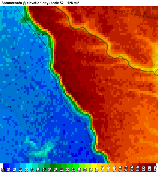
Below is the Elevation map of Sprâncenata, which displays elevation range with different colors. Scale of the first map is from 52 to 128 m (171 to 420 ft) with average elevation of 92.2 meters (=302 ft) [note 1]
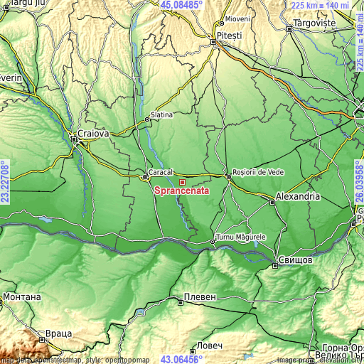
These maps also provides idea of topography and contour of this city, they are displayed at different zoom levels. More info about maps, scale and edge coordinates you can find below images.
| \ | Map #1 | Topo.Map |
| Scale [m] | 52..128 m | × |
| Scale [ft] | 171..420 ft | × |
| Average | 92.2 m = 302 ft | × |
| Width | 7.02 km = 4.4 mi | 224.6 km = 139.6 mi |
| Height | 7.02 km = 4.4 mi | 224.6 km = 139.6 mi |
| ↑Max Latitude | 44.114889° | 45.08485° |
| Latitude at center | 44.08333° | 44.08333° |
| ↓Min Latitude | 44.051754° | 43.06456° |
| ← Min Longitude | 24.589385° | 23.22708° |
| Longitude center | 24.63333° | 24.63333° |
| →Max Longitude | 24.677275° | 26.03958° |
Nearby cities:
Cities around Sprâncenata sort by population:
• Radomireşti elevation 106 m
5.4 km,  47°
47°
• Dăneasa 133 m
9.1 km,  324°
324°
• Gostavăţu 64 m
8 km,  270°
270°
• Scărişoara 57 m
10.7 km,  209°
209°
• Stoicăneşti 132 m
11.1 km,  0°
0°
• Stoeneşti 74 m
11.3 km,  289°
289°
• Băbiciu 62 m
7.7 km,  223°
223°
• Slăveni 71 m
8.4 km, 271°
• Călinești 109 m
4.4 km,  98°
98°
• Beciu 76 m
9.2 km,  163°
163°
• Dudu 84 m
12.1 km, 162°
• Crăciunei 117 m
7.3 km,  18°
18°
Multilingual:
 En español:
Sprâncenata elevación 121 m.
 En France:
Sprâncenata élévation 121 m.
 Auf Deutsch:
Sprâncenata höhe über dem Meeresspiegel ist 121 m.

Sources and notes:
- [note 1] Map square and city borders are not equal. Map elevation data is calculated only from area inside that square.
- [src 1] Elevation data from geonames database provided with same terms of usage.
- [src 2] The elevation map of Sprâncenata is generated using elevation data from NASA's 3 arcsec (90m) resolution SRTM data.
- [src 3] Base (background) map © OpenStreetMap contributors tiles are generated by Geofabrik and OpenTopoMap.
Copyright & License:
This Sprâncenata Elevation Map is licensed under CC BY-SA. You may reuse any part from this page, if you give a proper credit by linking to this URL:
 More info on terms of use page.