Crețești elevation
Crețești (Vaslui, Comuna Creţeşti), Romania elevation is 163 meters and Crețești elevation in feet is 535 ft above sea level [src 1]. Crețești is a seat of a second-order administrative division (feature code) with elevation that is 89 meters (292 ft) smaller than average city elevation in Romania.
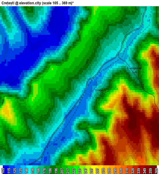
Below is the Elevation map of Crețești, which displays elevation range with different colors. Scale of the first map is from 105 to 369 m (344 to 1211 ft) with average elevation of 198.4 meters (=651 ft) [note 1]
These maps also provides idea of topography and contour of this city, they are displayed at different zoom levels. More info about maps, scale and edge coordinates you can find below images.
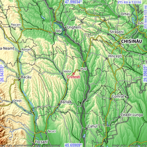
| \ | Map #1 | Topo.Map |
| Scale [m] | 105..369 m | × |
| Scale [ft] | 344..1211 ft | × |
| Average | 198.4 m = 651 ft | × |
| Width | 6.71 km = 4.2 mi | 214.7 km = 133.4 mi |
| Height | 6.71 km = 4.2 mi | 214.7 km = 133.4 mi |
| ↑Max Latitude | 46.663497° | 47.59034° |
| Latitude at center | 46.63333° | 46.63333° |
| ↓Min Latitude | 46.603146° | 45.65909° |
| ← Min Longitude | 27.906055° | 26.54375° |
| Longitude center | 27.95° | 27.95° |
| →Max Longitude | 27.993945° | 29.35625° |
Nearby cities:
Cities around Crețești sort by population:
• Huşi elevation 98 m
9.5 km,  61°
61°
• Văleni 163 m
9.7 km,  117°
117°
• Tanacu 211 m
11.6 km,  298°
298°
• Duda 204 m
14.8 km,  26°
26°
• Muntenii de Jos 161 m
14.1 km,  262°
262°
• Hoceni 142 m
11.3 km,  157°
157°
• Olteneşti 142 m
6.7 km,  214°
214°
• Epureni 133 m
10.7 km,  39°
39°
• Corni-Albești 224 m
14.1 km, 205°
• Muntenii de Sus 143 m
14.6 km, 295°
• Pădureni 122 m
10.2 km,  97°
97°
• Tătărăni 171 m
6.9 km,  9°
9°
Multilingual:
 En español:
Crețești elevación 163 m.
 En France:
Crețești élévation 163 m.
 Auf Deutsch:
Crețești höhe über dem Meeresspiegel ist 163 m.

Sources and notes:
- [note 1] Map square and city borders are not equal. Map elevation data is calculated only from area inside that square.
- [src 1] Elevation data from geonames database provided with same terms of usage.
- [src 2] The elevation map of Crețești is generated using elevation data from NASA's 3 arcsec (90m) resolution SRTM data.
- [src 3] Base (background) map © OpenStreetMap contributors tiles are generated by Geofabrik and OpenTopoMap.
Copyright & License:
This Crețești Elevation Map is licensed under CC BY-SA. You may reuse any part from this page, if you give a proper credit by linking to this URL:
 More info on terms of use page.