Tanacu elevation
Tanacu (Vaslui, Comuna Tanacu), Romania elevation is 211 meters and Tanacu elevation in feet is 692 ft above sea level [src 1]. Tanacu is a seat of a second-order administrative division (feature code) with elevation that is 41 meters (135 ft) smaller than average city elevation in Romania.
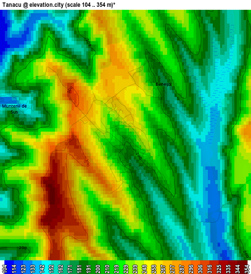
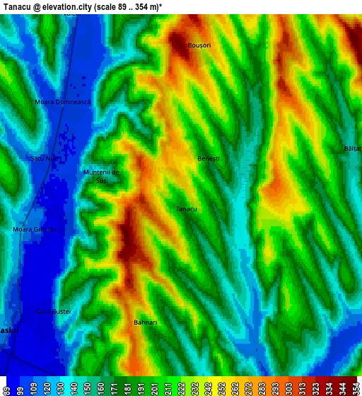
Below is the Elevation map of Tanacu, which displays elevation range with different colors. Scale of the first map is from 104 to 354 m (341 to 1161 ft) with average elevation of 211.1 meters (=693 ft) [note 1]
These maps also provides idea of topography and contour of this city, they are displayed at different zoom levels. More info about maps, scale and edge coordinates you can find below images.
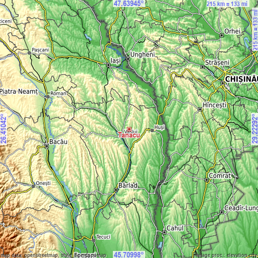
| \ | Map #1 | Map #2 | Topo.Map |
| Scale [m] | 104..354 m | 89..354 m | × |
| Scale [ft] | 341..1161 ft | 292..1161 ft | × |
| Average | 211.1 m = 693 ft | 185.4 m = 608 ft | × |
| Width | 6.7 km = 4.2 mi | 13.41 km = 8.3 mi | 214.5 km = 133.3 mi |
| Height | 6.7 km = 4.2 mi | 13.41 km = 8.3 mi | 214.5 km = 133.3 mi |
| ↑Max Latitude | 46.713469° | 46.743592° | 47.63945° |
| Latitude at center | 46.68333° | 46.68333° | 46.68333° |
| ↓Min Latitude | 46.653174° | 46.623001° | 45.70998° |
| ← Min Longitude | 27.772725° | 27.728779° | 26.41042° |
| Longitude center | 27.81667° | 27.81667° | 27.81667° |
| →Max Longitude | 27.860615° | 27.904561° | 29.22292° |
Nearby cities:
Cities around Tanacu sort by population:
• Vaslui elevation 96 m
8.4 km,  228°
228°
• Soleşti 108 m
9.6 km,  344°
344°
• Muntenii de Jos 161 m
8.3 km,  207°
207°
• Văleni 175 m
8.3 km,  328°
328°
• Satu Nou 109 m
5.4 km,  285°
285°
• Brodoc 100 m
11.3 km,  251°
251°
• Muntenii de Sus 143 m
3.1 km,  283°
283°
• Moara Domnească 105 m
5.6 km,  308°
308°
• Gugești 165 m
11 km,  35°
35°
• Moara Grecilor 115 m
5.6 km,  256°
256°
• Rediu 100 m
10.8 km,  239°
239°
• Tătărăni 171 m
11.3 km,  83°
83°
Multilingual:
 En español:
Tanacu elevación 211 m.
 En France:
Tanacu élévation 211 m.


Sources and notes:
- [note 1] Map square and city borders are not equal. Map elevation data is calculated only from area inside that square.
- [src 1] Elevation data from geonames database provided with same terms of usage.
- [src 2] The elevation map of Tanacu is generated using elevation data from NASA's 3 arcsec (90m) resolution SRTM data.
- [src 3] Base (background) map © OpenStreetMap contributors tiles are generated by Geofabrik and OpenTopoMap.
Copyright & License:
This Tanacu Elevation Map is licensed under CC BY-SA. You may reuse any part from this page, if you give a proper credit by linking to this URL:
 More info on terms of use page.