Cuejdiu elevation
Cuejdiu (Neamţ, Comuna Gârcina), Romania elevation is 480 meters and Cuejdiu elevation in feet is 1575 ft above sea level [src 1]. Cuejdiu is a populated place (feature code) with elevation that is 228 meters (748 ft) bigger than average city elevation in Romania.
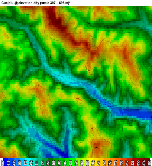
Below is the Elevation map of Cuejdiu, which displays elevation range with different colors. Scale of the first map is from 397 to 893 m (1302 to 2930 ft) with average elevation of 616.3 meters (=2022 ft) [note 1]
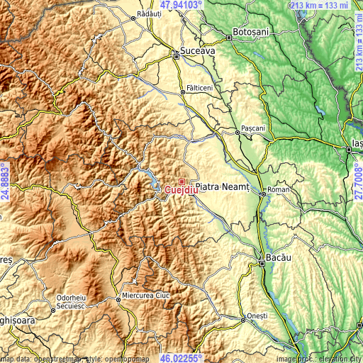
These maps also provides idea of topography and contour of this city, they are displayed at different zoom levels. More info about maps, scale and edge coordinates you can find below images.
| \ | Map #1 | Topo.Map |
| Scale [m] | 397..893 m | × |
| Scale [ft] | 1302..2930 ft | × |
| Average | 616.3 m = 2022 ft | × |
| Width | 6.67 km = 4.1 mi | 213.3 km = 132.5 mi |
| Height | 6.67 km = 4.1 mi | 213.3 km = 132.5 mi |
| ↑Max Latitude | 47.020368° | 47.94103° |
| Latitude at center | 46.9904° | 46.9904° |
| ↓Min Latitude | 46.960416° | 46.02255° |
| ← Min Longitude | 26.250605° | 24.8883° |
| Longitude center | 26.29455° | 26.29455° |
| →Max Longitude | 26.338495° | 27.7008° |
Nearby cities:
Cities around Cuejdiu sort by population:
• Piatra Neamţ elevation 508 m
8.7 km,  160°
160°
• Bodeşti 409 m
10.4 km,  62°
62°
• Viişoara 347 m
7.9 km,  216°
216°
• Poiana Crăcăoani 516 m
8.6 km,  11°
11°
• Dobreni 487 m
9.3 km,  94°
94°
• Gârcina 413 m
4.2 km,  111°
111°
• Bistrița 391 m
4.7 km,  178°
178°
• Negrești 431 m
7.8 km, 56°
• Pângărăcior 371 m
8.7 km, 222°
• Vădurele 361 m
7.2 km,  207°
207°
• Stejaru 371 m
11.8 km,  227°
227°
• Oanțu 432 m
11.5 km, 218°
Multilingual:
 En español:
Cuejdiu elevación 480 m.
 En France:
Cuejdiu élévation 480 m.


Sources and notes:
- [note 1] Map square and city borders are not equal. Map elevation data is calculated only from area inside that square.
- [src 1] Elevation data from geonames database provided with same terms of usage.
- [src 2] The elevation map of Cuejdiu is generated using elevation data from NASA's 3 arcsec (90m) resolution SRTM data.
- [src 3] Base (background) map © OpenStreetMap contributors tiles are generated by Geofabrik and OpenTopoMap.
Copyright & License:
This Cuejdiu Elevation Map is licensed under CC BY-SA. You may reuse any part from this page, if you give a proper credit by linking to this URL:
 More info on terms of use page.