Viişoara elevation
Viişoara (Neamţ, Comuna Pângăraţi), Romania elevation is 347 meters and Viişoara elevation in feet is 1138 ft above sea level [src 1]. Viişoara is a populated place (feature code) with elevation that is 95 meters (312 ft) bigger than average city elevation in Romania.
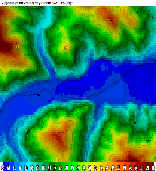
Below is the Elevation map of Viişoara, which displays elevation range with different colors. Scale of the first map is from 328 to 960 m (1076 to 3150 ft) with average elevation of 532.3 meters (=1746 ft) [note 1]
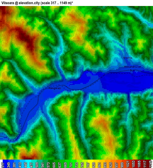
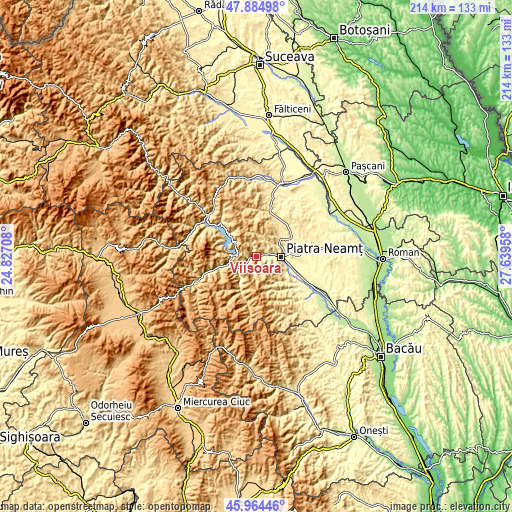
These maps also provides idea of topography and contour of this city, they are displayed at different zoom levels. More info about maps, scale and edge coordinates you can find below images.
| \ | Map #1 | Map #2 | Topo.Map |
| Scale [m] | 328..960 m | 317..1149 m | × |
| Scale [ft] | 1076..3150 ft | 1040..3770 ft | × |
| Average | 532.3 m = 1746 ft | 604.8 m = 1984 ft | × |
| Width | 6.67 km = 4.1 mi | 13.35 km = 8.3 mi | 213.5 km = 132.7 mi |
| Height | 6.67 km = 4.1 mi | 13.35 km = 8.3 mi | 213.5 km = 132.7 mi |
| ↑Max Latitude | 46.96333° | 46.993312° | 47.88498° |
| Latitude at center | 46.93333° | 46.93333° | 46.93333° |
| ↓Min Latitude | 46.903314° | 46.87328° | 45.96446° |
| ← Min Longitude | 26.189385° | 26.145439° | 24.82708° |
| Longitude center | 26.23333° | 26.23333° | 26.23333° |
| →Max Longitude | 26.277275° | 26.321221° | 27.63958° |
Nearby cities:
Cities around Viişoara sort by population:
• Piatra Neamţ elevation 508 m
7.8 km,  103°
103°
• Tarcău 466 m
10.6 km,  225°
225°
• Gârcina 413 m
9.8 km,  60°
60°
• Dodeni 425 m
10.7 km,  265°
265°
• Bistrița 391 m
5 km,  70°
70°
• Pângărăcior 371 m
1.3 km, 270°
• Cuejdiu 480 m
7.9 km,  36°
36°
• Văleni 306 m
12.3 km,  105°
105°
• Vădurele 361 m
1.3 km,  90°
90°
• Stejaru 371 m
4.3 km,  248°
248°
• Oanțu 432 m
3.7 km,  224°
224°
• Pângăraţi 735 m
6.3 km, 270°
Multilingual:
 En español:
Viişoara elevación 347 m.
 En France:
Viişoara élévation 347 m.
 Auf Deutsch:
Viişoara höhe über dem Meeresspiegel ist 347 m.

Sources and notes:
- [note 1] Map square and city borders are not equal. Map elevation data is calculated only from area inside that square.
- [src 1] Elevation data from geonames database provided with same terms of usage.
- [src 2] The elevation map of Viişoara is generated using elevation data from NASA's 3 arcsec (90m) resolution SRTM data.
- [src 3] Base (background) map © OpenStreetMap contributors tiles are generated by Geofabrik and OpenTopoMap.
Copyright & License:
This Viişoara Elevation Map is licensed under CC BY-SA. You may reuse any part from this page, if you give a proper credit by linking to this URL:
 More info on terms of use page.