Daia Română elevation
Daia Română (Alba, Comuna Daia Română), Romania elevation is 305 meters and Daia Română elevation in feet is 1001 ft above sea level [src 1]. Daia Română is a seat of a second-order administrative division (feature code) with elevation that is 53 meters (174 ft) bigger than average city elevation in Romania.
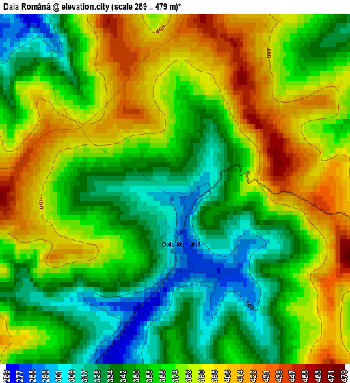
Below is the Elevation map of Daia Română, which displays elevation range with different colors. Scale of the first map is from 269 to 479 m (883 to 1572 ft) with average elevation of 366.9 meters (=1204 ft) [note 1]
These maps also provides idea of topography and contour of this city, they are displayed at different zoom levels. More info about maps, scale and edge coordinates you can find below images.
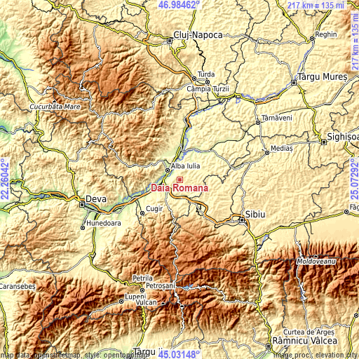
| \ | Map #1 | Topo.Map |
| Scale [m] | 269..479 m | × |
| Scale [ft] | 883..1572 ft | × |
| Average | 366.9 m = 1204 ft | × |
| Width | 6.79 km = 4.2 mi | 217.2 km = 135 mi |
| Height | 6.79 km = 4.2 mi | 217.2 km = 135 mi |
| ↑Max Latitude | 46.047179° | 46.98462° |
| Latitude at center | 46.01667° | 46.01667° |
| ↓Min Latitude | 45.986144° | 45.03148° |
| ← Min Longitude | 23.622725° | 22.26042° |
| Longitude center | 23.66667° | 23.66667° |
| →Max Longitude | 23.710615° | 25.07292° |
Nearby cities:
Cities around Daia Română sort by population:
• Alba Iulia elevation 219 m
8.5 km,  310°
310°
• Sebeş 254 m
10 km,  227°
227°
• Sântimbru 222 m
13 km,  354°
354°
• Ciugud 219 m
5.4 km, 313°
• Şpring 415 m
10.6 km,  121°
121°
• Oarda 219 m
7.9 km,  283°
283°
• Bărăbanț 227 m
11.1 km,  325°
325°
• Berghin 293 m
8.7 km,  38°
38°
• Lancrăm 238 m
9.1 km,  248°
248°
• Micești 244 m
12.7 km,  317°
317°
• Cut 290 m
8.6 km,  179°
179°
• Ohaba 330 m
10.6 km,  58°
58°
Multilingual:
 En español:
Daia Română elevación 305 m.
 En France:
Daia Română élévation 305 m.
 Auf Deutsch:
Daia Română höhe über dem Meeresspiegel ist 305 m.

Sources and notes:
- [note 1] Map square and city borders are not equal. Map elevation data is calculated only from area inside that square.
- [src 1] Elevation data from geonames database provided with same terms of usage.
- [src 2] The elevation map of Daia Română is generated using elevation data from NASA's 3 arcsec (90m) resolution SRTM data.
- [src 3] Base (background) map © OpenStreetMap contributors tiles are generated by Geofabrik and OpenTopoMap.
Copyright & License:
This Daia Română Elevation Map is licensed under CC BY-SA. You may reuse any part from this page, if you give a proper credit by linking to this URL:
 More info on terms of use page.