Ohaba elevation
Ohaba (Alba, Comuna Ohaba), Romania elevation is 330 meters and Ohaba elevation in feet is 1083 ft above sea level [src 1]. Ohaba is a seat of a second-order administrative division (feature code) with elevation that is 78 meters (256 ft) bigger than average city elevation in Romania.
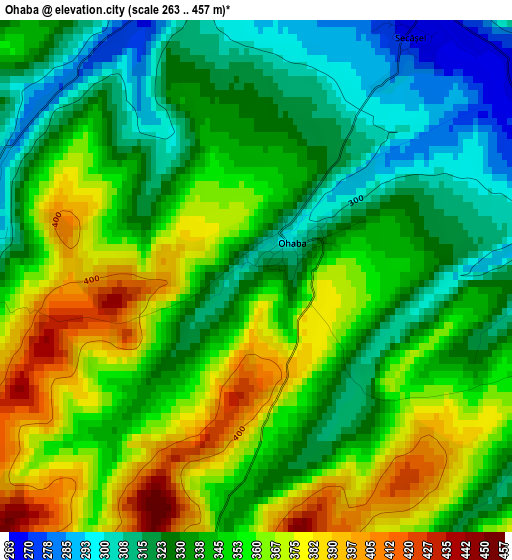
Below is the Elevation map of Ohaba, which displays elevation range with different colors. Scale of the first map is from 263 to 457 m (863 to 1499 ft) with average elevation of 344.9 meters (=1132 ft) [note 1]
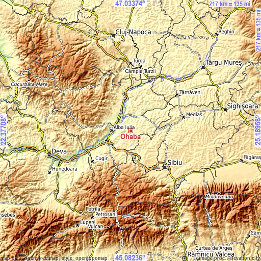
These maps also provides idea of topography and contour of this city, they are displayed at different zoom levels. More info about maps, scale and edge coordinates you can find below images.
| \ | Map #1 | Topo.Map |
| Scale [m] | 263..457 m | × |
| Scale [ft] | 863..1499 ft | × |
| Average | 344.9 m = 1132 ft | × |
| Width | 6.78 km = 4.2 mi | 217 km = 134.8 mi |
| Height | 6.78 km = 4.2 mi | 217 km = 134.8 mi |
| ↑Max Latitude | 46.097152° | 47.03374° |
| Latitude at center | 46.06667° | 46.06667° |
| ↓Min Latitude | 46.036171° | 45.08236° |
| ← Min Longitude | 23.739385° | 22.37708° |
| Longitude center | 23.78333° | 23.78333° |
| →Max Longitude | 23.827275° | 25.18958° |
Nearby cities:
Cities around Ohaba sort by population:
• Mihalţ elevation 345 m
10 km,  337°
337°
• Daia Română 305 m
10.6 km,  238°
238°
• Sântimbru 222 m
12.7 km,  305°
305°
• Ciugud 219 m
13 km,  261°
261°
• Şpring 415 m
11.1 km,  180°
180°
• Păuca 380 m
10.6 km,  121°
121°
• Berghin 293 m
3.8 km,  289°
289°
• Tiur 247 m
13.2 km,  38°
38°
• Cergău Mic 313 m
11.7 km,  80°
80°
• Roşia de Secaş 314 m
7.9 km,  103°
103°
• Doştat 385 m
12.3 km,  155°
155°
• Cergău Mare 303 m
11.3 km,  71°
71°
Multilingual:
 En español:
Ohaba elevación 330 m.
 En France:
Ohaba élévation 330 m.


Sources and notes:
- [note 1] Map square and city borders are not equal. Map elevation data is calculated only from area inside that square.
- [src 1] Elevation data from geonames database provided with same terms of usage.
- [src 2] The elevation map of Ohaba is generated using elevation data from NASA's 3 arcsec (90m) resolution SRTM data.
- [src 3] Base (background) map © OpenStreetMap contributors tiles are generated by Geofabrik and OpenTopoMap.
Copyright & License:
This Ohaba Elevation Map is licensed under CC BY-SA. You may reuse any part from this page, if you give a proper credit by linking to this URL:
 More info on terms of use page.