Dobreni elevation
Dobreni (Teleorman, Comuna Tătărăştii de Sus), Romania elevation is 127 meters and Dobreni elevation in feet is 417 ft above sea level [src 1]. Dobreni is a populated place (feature code) with elevation that is 125 meters (410 ft) smaller than average city elevation in Romania.
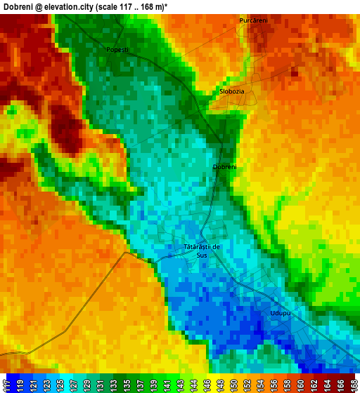
Below is the Elevation map of Dobreni, which displays elevation range with different colors. Scale of the first map is from 117 to 168 m (384 to 551 ft) with average elevation of 143.4 meters (=470 ft) [note 1]
These maps also provides idea of topography and contour of this city, they are displayed at different zoom levels. More info about maps, scale and edge coordinates you can find below images.
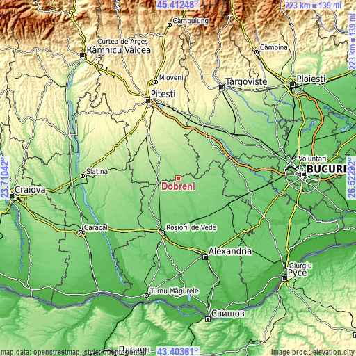
| \ | Map #1 | Topo.Map |
| Scale [m] | 117..168 m | × |
| Scale [ft] | 384..551 ft | × |
| Average | 143.4 m = 470 ft | × |
| Width | 6.98 km = 4.3 mi | 223.4 km = 138.8 mi |
| Height | 6.98 km = 4.3 mi | 223.4 km = 138.8 mi |
| ↑Max Latitude | 44.44805° | 45.41248° |
| Latitude at center | 44.41667° | 44.41667° |
| ↓Min Latitude | 44.385273° | 43.40361° |
| ← Min Longitude | 25.072725° | 23.71042° |
| Longitude center | 25.11667° | 25.11667° |
| →Max Longitude | 25.160615° | 26.52292° |
Nearby cities:
Cities around Dobreni sort by population:
• Poporogi elevation 114 m
7.7 km,  136°
136°
• Căldăraru 175 m
13.7 km,  285°
285°
• Izvoru 169 m
9.6 km,  334°
334°
• Siliștea Gumești 154 m
10 km,  248°
248°
• Ştefan cel Mare 159 m
13.2 km,  50°
50°
• Tătărăștii de Jos 122 m
6.7 km,  133°
133°
• Udupu 125 m
3.2 km, 134°
• Tătărăștii de Sus 123 m
1.1 km,  157°
157°
• Strâmbeni 169 m
12.8 km,  297°
297°
• Surdulești 161 m
12.9 km,  257°
257°
• Râca 166 m
6.1 km, 288°
• Popeşti 134 m
3.1 km, 334°
Multilingual:
 En español:
Dobreni elevación 127 m.
 En France:
Dobreni élévation 127 m.


Sources and notes:
- [note 1] Map square and city borders are not equal. Map elevation data is calculated only from area inside that square.
- [src 1] Elevation data from geonames database provided with same terms of usage.
- [src 2] The elevation map of Dobreni is generated using elevation data from NASA's 3 arcsec (90m) resolution SRTM data.
- [src 3] Base (background) map © OpenStreetMap contributors tiles are generated by Geofabrik and OpenTopoMap.
Copyright & License:
This Dobreni Elevation Map is licensed under CC BY-SA. You may reuse any part from this page, if you give a proper credit by linking to this URL:
 More info on terms of use page.