Surdulești elevation
Surdulești (Arges, Comuna Miroşi), Romania elevation is 161 meters and Surdulești elevation in feet is 528 ft above sea level [src 1]. Surdulești is a populated place (feature code) with elevation that is 91 meters (299 ft) smaller than average city elevation in Romania.
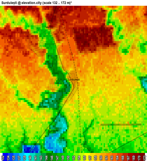
Below is the Elevation map of Surdulești, which displays elevation range with different colors. Scale of the first map is from 132 to 172 m (433 to 564 ft) with average elevation of 156.7 meters (=514 ft) [note 1]
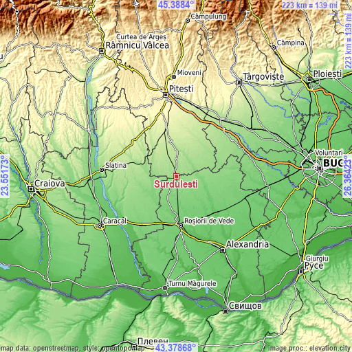
These maps also provides idea of topography and contour of this city, they are displayed at different zoom levels. More info about maps, scale and edge coordinates you can find below images.
| \ | Map #1 | Topo.Map |
| Scale [m] | 132..172 m | × |
| Scale [ft] | 433..564 ft | × |
| Average | 156.7 m = 514 ft | × |
| Width | 6.98 km = 4.3 mi | 223.5 km = 138.9 mi |
| Height | 6.98 km = 4.3 mi | 223.4 km = 138.8 mi |
| ↑Max Latitude | 44.423564° | 45.3884° |
| Latitude at center | 44.39217° | 44.39217° |
| ↓Min Latitude | 44.36076° | 43.37868° |
| ← Min Longitude | 24.914035° | 23.55173° |
| Longitude center | 24.95798° | 24.95798° |
| →Max Longitude | 25.001925° | 26.36423° |
Nearby cities:
Cities around Surdulești sort by population:
• Ungheni elevation 189 m
12 km,  3°
3°
• Dobreni 127 m
12.9 km,  77°
77°
• Căldăraru 175 m
6.5 km,  354°
354°
• Miroşi 158 m
3.4 km,  324°
324°
• Siliștea Gumești 154 m
3.5 km,  106°
106°
• Balaci 147 m
5.7 km,  215°
215°
• Zâmbreasca 139 m
8.6 km,  166°
166°
• Tătărăștii de Sus 123 m
13.1 km, 82°
• Strâmbeni 169 m
8.6 km,  8°
8°
• Tecuci 145 m
9.6 km,  234°
234°
• Râca 166 m
8.2 km,  55°
55°
• Popeşti 134 m
12.6 km, 63°
Multilingual:
 En español:
Surdulești elevación 161 m.
 En France:
Surdulești élévation 161 m.
 Auf Deutsch:
Surdulești höhe über dem Meeresspiegel ist 161 m.

Sources and notes:
- [note 1] Map square and city borders are not equal. Map elevation data is calculated only from area inside that square.
- [src 1] Elevation data from geonames database provided with same terms of usage.
- [src 2] The elevation map of Surdulești is generated using elevation data from NASA's 3 arcsec (90m) resolution SRTM data.
- [src 3] Base (background) map © OpenStreetMap contributors tiles are generated by Geofabrik and OpenTopoMap.
Copyright & License:
This Surdulești Elevation Map is licensed under CC BY-SA. You may reuse any part from this page, if you give a proper credit by linking to this URL:
 More info on terms of use page.