Drăghici elevation
Drăghici (Arges, Comuna Mihăeşti), Romania elevation is 446 meters and Drăghici elevation in feet is 1463 ft above sea level [src 1]. Drăghici is a populated place (feature code) with elevation that is 194 meters (636 ft) bigger than average city elevation in Romania.
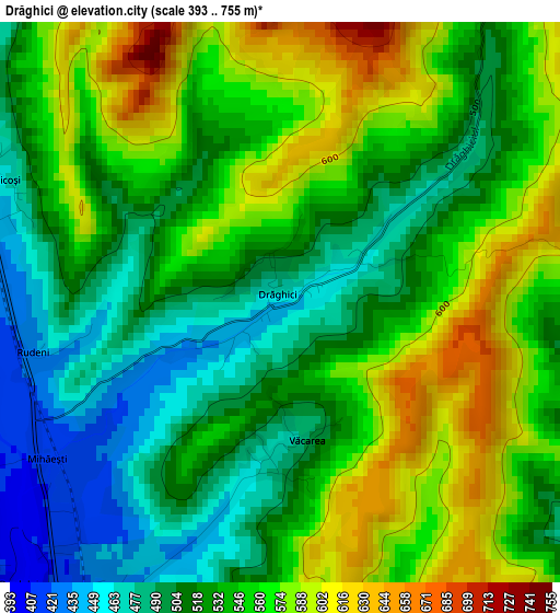
Below is the Elevation map of Drăghici, which displays elevation range with different colors. Scale of the first map is from 393 to 755 m (1289 to 2477 ft) with average elevation of 538.7 meters (=1767 ft) [note 1]
These maps also provides idea of topography and contour of this city, they are displayed at different zoom levels. More info about maps, scale and edge coordinates you can find below images.
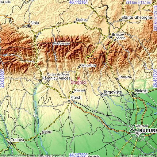
| \ | Map #1 | Topo.Map |
| Scale [m] | 393..755 m | × |
| Scale [ft] | 1289..2477 ft | × |
| Average | 538.7 m = 1767 ft | × |
| Width | 6.89 km = 4.3 mi | 220.6 km = 137.1 mi |
| Height | 6.89 km = 4.3 mi | 220.6 km = 137.1 mi |
| ↑Max Latitude | 45.159646° | 46.11216° |
| Latitude at center | 45.12865° | 45.12865° |
| ↓Min Latitude | 45.097637° | 44.12789° |
| ← Min Longitude | 25.001135° | 23.63883° |
| Longitude center | 25.04508° | 25.04508° |
| →Max Longitude | 25.089025° | 26.45133° |
Nearby cities:
Cities around Drăghici sort by population:
• Mihăeşti elevation 410 m
3.8 km,  249°
249°
• Schitu-Goleşti 509 m
8.7 km,  335°
335°
• Hârtieşti 466 m
4.5 km,  107°
107°
• Poienari 593 m
9.8 km,  2°
2°
• Boteni 543 m
8.3 km,  42°
42°
• Vlădești 461 m
10.3 km,  283°
283°
• Lăzărești 454 m
5 km,  308°
308°
• Vulturești 420 m
7.6 km,  156°
156°
• Jugur 577 m
7.8 km,  23°
23°
• Rădești 388 m
7.2 km,  208°
208°
• Capu Piscului 476 m
7.8 km,  316°
316°
• Valea Popii 444 m
4.4 km,  203°
203°
Multilingual:
 En español:
Drăghici elevación 446 m.
 En France:
Drăghici élévation 446 m.
 Auf Deutsch:
Drăghici höhe über dem Meeresspiegel ist 446 m.

Sources and notes:
- [note 1] Map square and city borders are not equal. Map elevation data is calculated only from area inside that square.
- [src 1] Elevation data from geonames database provided with same terms of usage.
- [src 2] The elevation map of Drăghici is generated using elevation data from NASA's 3 arcsec (90m) resolution SRTM data.
- [src 3] Base (background) map © OpenStreetMap contributors tiles are generated by Geofabrik and OpenTopoMap.
Copyright & License:
This Drăghici Elevation Map is licensed under CC BY-SA. You may reuse any part from this page, if you give a proper credit by linking to this URL:
 More info on terms of use page.