Jugur elevation
Jugur (Arges, Comuna Poienarii de Muscel), Romania elevation is 577 meters and Jugur elevation in feet is 1893 ft above sea level [src 1]. Jugur is a populated place (feature code) with elevation that is 325 meters (1066 ft) bigger than average city elevation in Romania.
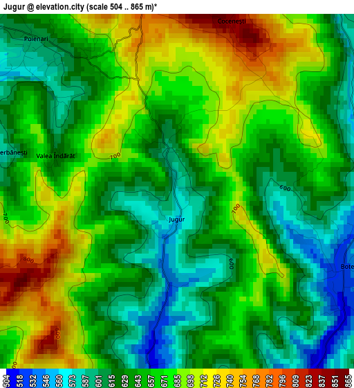
Below is the Elevation map of Jugur, which displays elevation range with different colors. Scale of the first map is from 504 to 865 m (1654 to 2838 ft) with average elevation of 653.6 meters (=2144 ft) [note 1]
These maps also provides idea of topography and contour of this city, they are displayed at different zoom levels. More info about maps, scale and edge coordinates you can find below images.
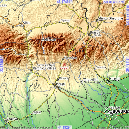
| \ | Map #1 | Topo.Map |
| Scale [m] | 504..865 m | × |
| Scale [ft] | 1654..2838 ft | × |
| Average | 653.6 m = 2144 ft | × |
| Width | 6.89 km = 4.3 mi | 220.4 km = 136.9 mi |
| Height | 6.89 km = 4.3 mi | 220.4 km = 136.9 mi |
| ↑Max Latitude | 45.223511° | 46.17494° |
| Latitude at center | 45.19255° | 45.19255° |
| ↓Min Latitude | 45.161572° | 44.1929° |
| ← Min Longitude | 25.040985° | 23.67868° |
| Longitude center | 25.08493° | 25.08493° |
| →Max Longitude | 25.128875° | 26.49118° |
Nearby cities:
Cities around Jugur sort by population:
• Schitu-Goleşti elevation 509 m
6.7 km,  277°
277°
• Hârtieşti 466 m
8.5 km,  172°
172°
• Stoeneşti 626 m
9 km,  45°
45°
• Poienari 593 m
3.8 km,  314°
314°
• Cetăţeni 872 m
7.8 km,  83°
83°
• Boteni 543 m
2.7 km,  112°
112°
• Văleni-Dâmbovița 522 m
8.2 km, 110°
• Lăzărești 454 m
8.1 km,  240°
240°
• Drăghici 446 m
7.8 km,  203°
203°
• Capu Piscului 476 m
8.6 km,  260°
260°
• Mățău 896 m
4.8 km,  358°
358°
• Câmpulung 593 m
8.7 km,  341°
341°
Multilingual:
 En español:
Jugur elevación 577 m.
 En France:
Jugur élévation 577 m.


Sources and notes:
- [note 1] Map square and city borders are not equal. Map elevation data is calculated only from area inside that square.
- [src 1] Elevation data from geonames database provided with same terms of usage.
- [src 2] The elevation map of Jugur is generated using elevation data from NASA's 3 arcsec (90m) resolution SRTM data.
- [src 3] Base (background) map © OpenStreetMap contributors tiles are generated by Geofabrik and OpenTopoMap.
Copyright & License:
This Jugur Elevation Map is licensed under CC BY-SA. You may reuse any part from this page, if you give a proper credit by linking to this URL:
 More info on terms of use page.