Câmpulung elevation
Câmpulung (Arges, Municipiul Câmpulung), Romania elevation is 593 meters and Câmpulung elevation in feet is 1946 ft above sea level [src 1]. Câmpulung is a seat of a second-order administrative division (feature code) with elevation that is 341 meters (1119 ft) bigger than average city elevation in Romania.
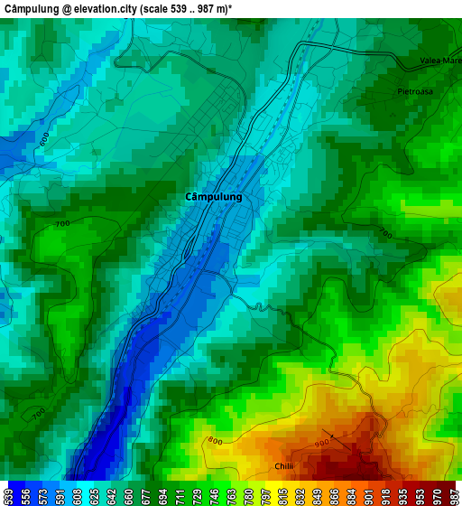
Below is the Elevation map of Câmpulung, which displays elevation range with different colors. Scale of the first map is from 539 to 987 m (1768 to 3238 ft) with average elevation of 682.5 meters (=2239 ft) [note 1]
These maps also provides idea of topography and contour of this city, they are displayed at different zoom levels. More info about maps, scale and edge coordinates you can find below images.
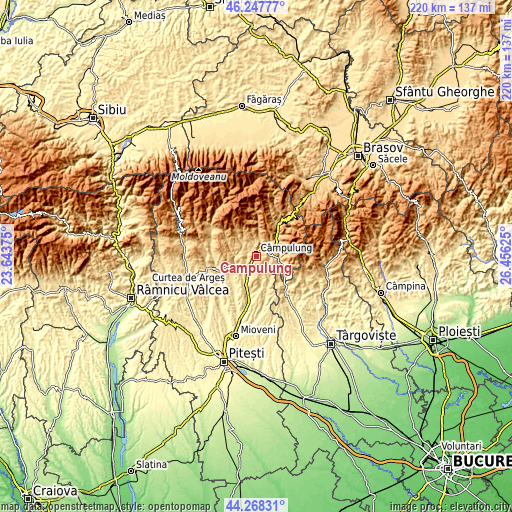
| \ | Map #1 | Topo.Map |
| Scale [m] | 539..987 m | × |
| Scale [ft] | 1768..3238 ft | × |
| Average | 682.5 m = 2239 ft | × |
| Width | 6.88 km = 4.3 mi | 220.1 km = 136.8 mi |
| Height | 6.88 km = 4.3 mi | 220.1 km = 136.8 mi |
| ↑Max Latitude | 45.297591° | 46.24777° |
| Latitude at center | 45.26667° | 45.26667° |
| ↓Min Latitude | 45.235733° | 44.26831° |
| ← Min Longitude | 25.006055° | 23.64375° |
| Longitude center | 25.05° | 25.05° |
| →Max Longitude | 25.093945° | 26.45625° |
Nearby cities:
Cities around Câmpulung sort by population:
• Lereşti elevation 700 m
7.5 km,  9°
9°
• Schitu-Goleşti 509 m
8.4 km,  207°
207°
• Stoeneşti 626 m
9.3 km,  101°
101°
• Albeşti 694 m
5.8 km,  325°
325°
• Poienari 593 m
5.6 km,  180°
180°
• Godeni 552 m
6.4 km,  234°
234°
• Bughea de Jos 580 m
3.9 km,  270°
270°
• Bughea de Sus 618 m
3.7 km,  338°
338°
• Valea Mare Pravăț 693 m
4.3 km,  50°
50°
• Voinești 644 m
4.1 km,  25°
25°
• Jugur 577 m
8.7 km,  161°
161°
• Mățău 896 m
4.3 km,  143°
143°
Multilingual:
 En español:
Câmpulung elevación 593 m.
 En France:
Câmpulung élévation 593 m.
 Auf Deutsch:
Câmpulung höhe über dem Meeresspiegel ist 593 m.

Sources and notes:
- [note 1] Map square and city borders are not equal. Map elevation data is calculated only from area inside that square.
- [src 1] Elevation data from geonames database provided with same terms of usage.
- [src 2] The elevation map of Câmpulung is generated using elevation data from NASA's 3 arcsec (90m) resolution SRTM data.
- [src 3] Base (background) map © OpenStreetMap contributors tiles are generated by Geofabrik and OpenTopoMap.
Copyright & License:
This Câmpulung Elevation Map is licensed under CC BY-SA. You may reuse any part from this page, if you give a proper credit by linking to this URL:
 More info on terms of use page.