Mihăeşti elevation
Mihăeşti (Arges, Comuna Mihăeşti), Romania elevation is 410 meters and Mihăeşti elevation in feet is 1345 ft above sea level [src 1]. Mihăeşti is a seat of a second-order administrative division (feature code) with elevation that is 158 meters (518 ft) bigger than average city elevation in Romania.
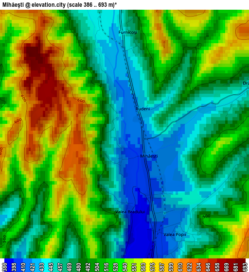
Below is the Elevation map of Mihăeşti, which displays elevation range with different colors. Scale of the first map is from 386 to 693 m (1266 to 2274 ft) with average elevation of 504.4 meters (=1655 ft) [note 1]
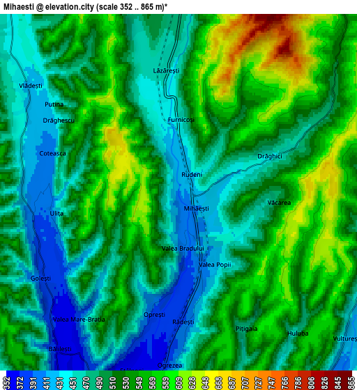
These maps also provides idea of topography and contour of this city, they are displayed at different zoom levels. More info about maps, scale and edge coordinates you can find below images.
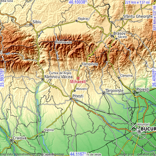
| \ | Map #1 | Map #2 | Topo.Map |
| Scale [m] | 386..693 m | 352..865 m | × |
| Scale [ft] | 1266..2274 ft | 1155..2838 ft | × |
| Average | 504.4 m = 1655 ft | 512.7 m = 1682 ft | × |
| Width | 6.9 km = 4.3 mi | 13.79 km = 8.6 mi | 220.7 km = 137.1 mi |
| Height | 6.9 km = 4.3 mi | 13.79 km = 8.6 mi | 220.7 km = 137.1 mi |
| ↑Max Latitude | 45.147672° | 45.178658° | 46.10038° |
| Latitude at center | 45.11667° | 45.11667° | 45.11667° |
| ↓Min Latitude | 45.085651° | 45.054615° | 44.1157° |
| ← Min Longitude | 24.956055° | 24.912109° | 23.59375° |
| Longitude center | 25° | 25° | 25° |
| →Max Longitude | 25.043945° | 25.087891° | 26.40625° |
Nearby cities:
Cities around Mihăeşti sort by population:
• Stâlpeni elevation 356 m
7.9 km,  199°
199°
• Hârtieşti 466 m
7.8 km,  90°
90°
• Bălileşti 476 m
7.6 km,  223°
223°
• Aninoasa 557 m
9.1 km,  324°
324°
• Vlădești 461 m
7.5 km,  299°
299°
• Lăzărești 454 m
4.5 km,  355°
355°
• Vulturești 420 m
8.6 km,  130°
130°
• Livezeni 370 m
8.9 km,  191°
191°
• Rădești 388 m
5 km,  178°
178°
• Drăghici 446 m
3.8 km,  69°
69°
• Capu Piscului 476 m
7.3 km,  345°
345°
• Valea Popii 444 m
3.2 km,  146°
146°
Multilingual:
 En español:
Mihăeşti elevación 410 m.
 En France:
Mihăeşti élévation 410 m.
 Auf Deutsch:
Mihăeşti höhe über dem Meeresspiegel ist 410 m.

Sources and notes:
- [note 1] Map square and city borders are not equal. Map elevation data is calculated only from area inside that square.
- [src 1] Elevation data from geonames database provided with same terms of usage.
- [src 2] The elevation map of Mihăeşti is generated using elevation data from NASA's 3 arcsec (90m) resolution SRTM data.
- [src 3] Base (background) map © OpenStreetMap contributors tiles are generated by Geofabrik and OpenTopoMap.
Copyright & License:
This Mihăeşti Elevation Map is licensed under CC BY-SA. You may reuse any part from this page, if you give a proper credit by linking to this URL:
 More info on terms of use page.