Aninoasa elevation
Aninoasa (Arges, Comuna Aninoasa), Romania elevation is 557 meters and Aninoasa elevation in feet is 1827 ft above sea level [src 1]. Aninoasa is a seat of a second-order administrative division (feature code) with elevation that is 305 meters (1001 ft) bigger than average city elevation in Romania.
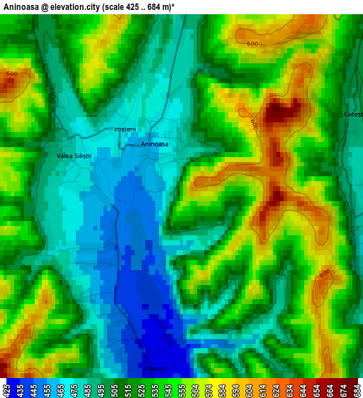
Below is the Elevation map of Aninoasa, which displays elevation range with different colors. Scale of the first map is from 425 to 684 m (1394 to 2244 ft) with average elevation of 521.2 meters (=1710 ft) [note 1]
These maps also provides idea of topography and contour of this city, they are displayed at different zoom levels. More info about maps, scale and edge coordinates you can find below images.
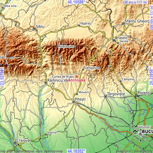
| \ | Map #1 | Topo.Map |
| Scale [m] | 425..684 m | × |
| Scale [ft] | 1394..2244 ft | × |
| Average | 521.2 m = 1710 ft | × |
| Width | 6.89 km = 4.3 mi | 220.4 km = 136.9 mi |
| Height | 6.89 km = 4.3 mi | 220.4 km = 136.9 mi |
| ↑Max Latitude | 45.214296° | 46.16589° |
| Latitude at center | 45.18333° | 45.18333° |
| ↓Min Latitude | 45.152347° | 44.18352° |
| ← Min Longitude | 24.889385° | 23.52708° |
| Longitude center | 24.93333° | 24.93333° |
| →Max Longitude | 24.977275° | 26.33958° |
Nearby cities:
Cities around Aninoasa sort by population:
• Pietroşani elevation 437 m
6.5 km,  270°
270°
• Mihăeşti 410 m
9.1 km,  144°
144°
• Schitu-Goleşti 509 m
5.5 km,  70°
70°
• Berevoeşti 608 m
5.7 km,  346°
346°
• Godeni 552 m
6.8 km,  35°
35°
• Domneşti 496 m
8.1 km,  283°
283°
• Vlădești 461 m
3.9 km,  199°
199°
• Lăzărești 454 m
5.7 km,  121°
121°
• Retevoiești 426 m
8.9 km,  237°
237°
• Bădești 449 m
5.8 km,  257°
257°
• Capu Piscului 476 m
3.4 km,  96°
96°
• Slănic 548 m
6.1 km,  329°
329°
Multilingual:
 En español:
Aninoasa elevación 557 m.
 En France:
Aninoasa élévation 557 m.
 Auf Deutsch:
Aninoasa höhe über dem Meeresspiegel ist 557 m.

Sources and notes:
- [note 1] Map square and city borders are not equal. Map elevation data is calculated only from area inside that square.
- [src 1] Elevation data from geonames database provided with same terms of usage.
- [src 2] The elevation map of Aninoasa is generated using elevation data from NASA's 3 arcsec (90m) resolution SRTM data.
- [src 3] Base (background) map © OpenStreetMap contributors tiles are generated by Geofabrik and OpenTopoMap.
Copyright & License:
This Aninoasa Elevation Map is licensed under CC BY-SA. You may reuse any part from this page, if you give a proper credit by linking to this URL:
 More info on terms of use page.