Dranovățu elevation
Dranovățu (Olt, Comuna Găneasa), Romania elevation is 115 meters and Dranovățu elevation in feet is 377 ft above sea level [src 1]. Dranovățu is a populated place (feature code) with elevation that is 137 meters (449 ft) smaller than average city elevation in Romania.
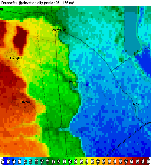
Below is the Elevation map of Dranovățu, which displays elevation range with different colors. Scale of the first map is from 103 to 156 m (338 to 512 ft) with average elevation of 122 meters (=400 ft) [note 1]
These maps also provides idea of topography and contour of this city, they are displayed at different zoom levels. More info about maps, scale and edge coordinates you can find below images.
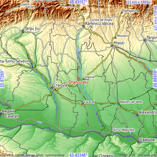
| \ | Map #1 | Topo.Map |
| Scale [m] | 103..156 m | × |
| Scale [ft] | 338..512 ft | × |
| Average | 122 m = 400 ft | × |
| Width | 6.98 km = 4.3 mi | 223.3 km = 138.8 mi |
| Height | 6.98 km = 4.3 mi | 223.3 km = 138.8 mi |
| ↑Max Latitude | 44.46756° | 45.43167° |
| Latitude at center | 44.43619° | 44.43619° |
| ↓Min Latitude | 44.404803° | 43.42346° |
| ← Min Longitude | 24.234995° | 22.87269° |
| Longitude center | 24.27894° | 24.27894° |
| →Max Longitude | 24.322885° | 25.68519° |
Nearby cities:
Cities around Dranovățu sort by population:
• Slatina elevation 165 m
7 km,  92°
92°
• Piatra Olt 132 m
7.8 km,  187°
187°
• Curtişoara 122 m
8.3 km,  31°
31°
• Găneasa 107 m
2.2 km,  170°
170°
• Bobiceşti 151 m
11.8 km,  240°
240°
• Strejeşti 139 m
10.8 km,  354°
354°
• Pleşoiu 127 m
3.5 km,  343°
343°
• Teslui 160 m
11.3 km,  37°
37°
• Slătioara 107 m
5 km,  143°
143°
• Piatra 123 m
8.5 km, 171°
• Dobrotinet 181 m
7.3 km,  48°
48°
• Cepari 153 m
10.9 km,  308°
308°
Multilingual:
 En español:
Dranovățu elevación 115 m.
 En France:
Dranovățu élévation 115 m.
 Auf Deutsch:
Dranovățu höhe über dem Meeresspiegel ist 115 m.

Sources and notes:
- [note 1] Map square and city borders are not equal. Map elevation data is calculated only from area inside that square.
- [src 1] Elevation data from geonames database provided with same terms of usage.
- [src 2] The elevation map of Dranovățu is generated using elevation data from NASA's 3 arcsec (90m) resolution SRTM data.
- [src 3] Base (background) map © OpenStreetMap contributors tiles are generated by Geofabrik and OpenTopoMap.
Copyright & License:
This Dranovățu Elevation Map is licensed under CC BY-SA. You may reuse any part from this page, if you give a proper credit by linking to this URL:
 More info on terms of use page.