Teslui elevation
Teslui (Olt, Comuna Teslui), Romania elevation is 160 meters and Teslui elevation in feet is 525 ft above sea level [src 1]. Teslui is a seat of a second-order administrative division (feature code) with elevation that is 92 meters (302 ft) smaller than average city elevation in Romania.
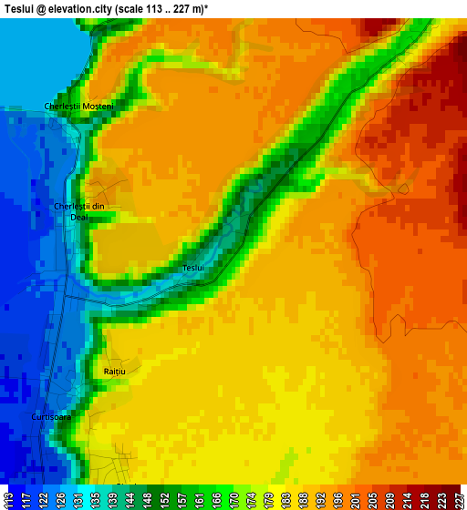
Below is the Elevation map of Teslui, which displays elevation range with different colors. Scale of the first map is from 113 to 227 m (371 to 745 ft) with average elevation of 176.4 meters (=579 ft) [note 1]
These maps also provides idea of topography and contour of this city, they are displayed at different zoom levels. More info about maps, scale and edge coordinates you can find below images.
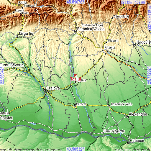
| \ | Map #1 | Topo.Map |
| Scale [m] | 113..227 m | × |
| Scale [ft] | 371..745 ft | × |
| Average | 176.4 m = 579 ft | × |
| Width | 6.97 km = 4.3 mi | 223 km = 138.6 mi |
| Height | 6.97 km = 4.3 mi | 223 km = 138.6 mi |
| ↑Max Latitude | 44.547997° | 45.51076° |
| Latitude at center | 44.51667° | 44.51667° |
| ↓Min Latitude | 44.485327° | 43.50532° |
| ← Min Longitude | 24.322725° | 22.96042° |
| Longitude center | 24.36667° | 24.36667° |
| →Max Longitude | 24.410615° | 25.77292° |
Nearby cities:
Cities around Teslui sort by population:
• Slatina elevation 165 m
9.3 km,  180°
180°
• Curtişoara 122 m
3.2 km,  234°
234°
• Valea Mare 198 m
7.7 km,  136°
136°
• Strejeşti 139 m
8.1 km,  283°
283°
• Pleşoiu 127 m
9.7 km, 234°
• Grădinari 142 m
9.7 km,  305°
305°
• Priseaca 218 m
6.6 km,  90°
90°
• Strejeștii de Sus 153 m
11.4 km,  285°
285°
• Voiceşti 135 m
11.4 km,  324°
324°
• Oporelu 250 m
10.1 km,  23°
23°
• Dobrotinet 181 m
4.4 km,  200°
200°
• Dranovățu 115 m
11.3 km,  217°
217°
Multilingual:
 En español:
Teslui elevación 160 m.
 En France:
Teslui élévation 160 m.


Sources and notes:
- [note 1] Map square and city borders are not equal. Map elevation data is calculated only from area inside that square.
- [src 1] Elevation data from geonames database provided with same terms of usage.
- [src 2] The elevation map of Teslui is generated using elevation data from NASA's 3 arcsec (90m) resolution SRTM data.
- [src 3] Base (background) map © OpenStreetMap contributors tiles are generated by Geofabrik and OpenTopoMap.
Copyright & License:
This Teslui Elevation Map is licensed under CC BY-SA. You may reuse any part from this page, if you give a proper credit by linking to this URL:
 More info on terms of use page.