Ferești elevation
Ferești (Vaslui, Comuna Fereşti), Romania elevation is 168 meters and Ferești elevation in feet is 551 ft above sea level [src 1]. Ferești is a seat of a second-order administrative division (feature code) with elevation that is 84 meters (276 ft) smaller than average city elevation in Romania.
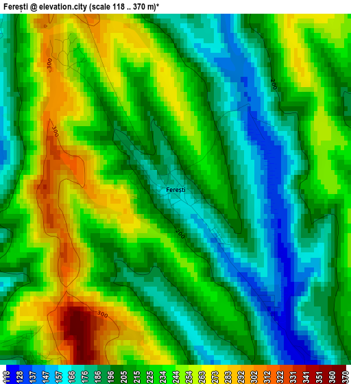
Below is the Elevation map of Ferești, which displays elevation range with different colors. Scale of the first map is from 118 to 370 m (387 to 1214 ft) with average elevation of 218.7 meters (=718 ft) [note 1]
These maps also provides idea of topography and contour of this city, they are displayed at different zoom levels. More info about maps, scale and edge coordinates you can find below images.
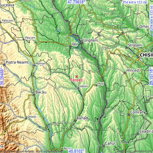
| \ | Map #1 | Topo.Map |
| Scale [m] | 118..370 m | × |
| Scale [ft] | 387..1214 ft | × |
| Average | 218.7 m = 718 ft | × |
| Width | 6.69 km = 4.2 mi | 214.1 km = 133 mi |
| Height | 6.69 km = 4.2 mi | 214.1 km = 133 mi |
| ↑Max Latitude | 46.811874° | 47.73615° |
| Latitude at center | 46.78179° | 46.78179° |
| ↓Min Latitude | 46.751689° | 45.8102° |
| ← Min Longitude | 27.656985° | 26.29468° |
| Longitude center | 27.70093° | 27.70093° |
| →Max Longitude | 27.744875° | 29.10718° |
Nearby cities:
Cities around Ferești sort by population:
• Codăeşti elevation 203 m
10.1 km,  21°
21°
• Zăpodeni 160 m
5.2 km,  227°
227°
• Soleşti 108 m
6.5 km,  104°
104°
• Ştefan cel Mare 106 m
9.1 km,  217°
217°
• Văleni 175 m
5.9 km,  130°
130°
• Micleşti 181 m
10.8 km,  68°
68°
• Dăneşti 216 m
8 km,  341°
341°
• Satu Nou 109 m
10.2 km,  159°
159°
• Muntenii de Sus 143 m
11.8 km,  150°
150°
• Moara Domnească 105 m
8.7 km, 149°
• Emil Racoviță 243 m
10.1 km,  350°
350°
• Bârzești 190 m
12 km,  252°
252°
Multilingual:
 En español:
Ferești elevación 168 m.
 En France:
Ferești élévation 168 m.


Sources and notes:
- [note 1] Map square and city borders are not equal. Map elevation data is calculated only from area inside that square.
- [src 1] Elevation data from geonames database provided with same terms of usage.
- [src 2] The elevation map of Ferești is generated using elevation data from NASA's 3 arcsec (90m) resolution SRTM data.
- [src 3] Base (background) map © OpenStreetMap contributors tiles are generated by Geofabrik and OpenTopoMap.
Copyright & License:
This Ferești Elevation Map is licensed under CC BY-SA. You may reuse any part from this page, if you give a proper credit by linking to this URL:
 More info on terms of use page.