Codăeşti elevation
Codăeşti (Vaslui, Comuna Codăeşti), Romania elevation is 203 meters and Codăeşti elevation in feet is 666 ft above sea level [src 1]. Codăeşti is a seat of a second-order administrative division (feature code) with elevation that is 49 meters (161 ft) smaller than average city elevation in Romania.
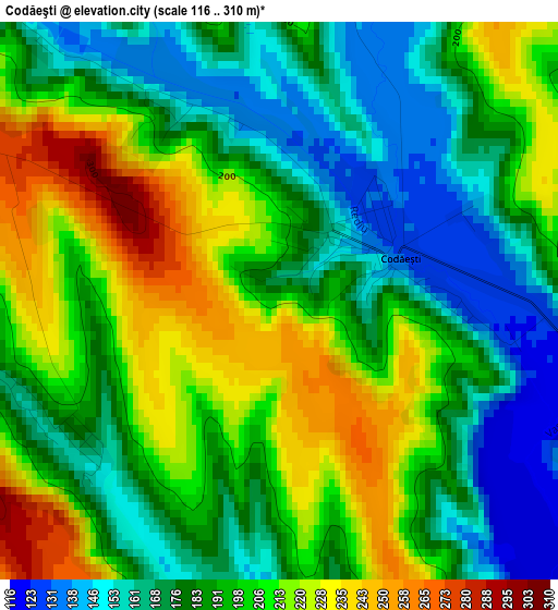
Below is the Elevation map of Codăeşti, which displays elevation range with different colors. Scale of the first map is from 116 to 310 m (381 to 1017 ft) with average elevation of 192.8 meters (=633 ft) [note 1]
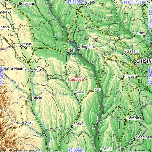
These maps also provides idea of topography and contour of this city, they are displayed at different zoom levels. More info about maps, scale and edge coordinates you can find below images.
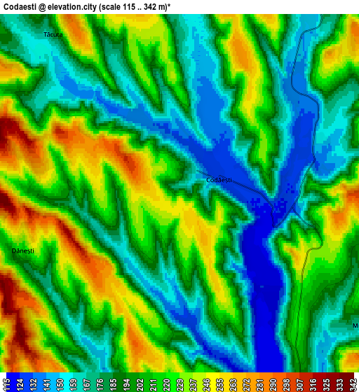
| \ | Map #1 | Map #2 | Topo.Map |
| Scale [m] | 116..310 m | 115..342 m | × |
| Scale [ft] | 381..1017 ft | 377..1122 ft | × |
| Average | 192.8 m = 633 ft | 200.4 m = 657 ft | × |
| Width | 6.68 km = 4.2 mi | 13.36 km = 8.3 mi | 213.8 km = 132.8 mi |
| Height | 6.68 km = 4.2 mi | 13.36 km = 8.3 mi | 213.8 km = 132.8 mi |
| ↑Max Latitude | 46.896707° | 46.926727° | 47.81952° |
| Latitude at center | 46.86667° | 46.86667° | 46.86667° |
| ↓Min Latitude | 46.836616° | 46.806546° | 45.8966° |
| ← Min Longitude | 27.706055° | 27.662109° | 26.34375° |
| Longitude center | 27.75° | 27.75° | 27.75° |
| →Max Longitude | 27.793945° | 27.837891° | 29.15625° |
Nearby cities:
Cities around Codăeşti sort by population:
• Ciorteşti elevation 167 m
7.3 km,  59°
59°
• Soleşti 108 m
11.4 km,  167°
167°
• Tăcuta 155 m
7.5 km,  317°
317°
• Micleşti 181 m
8.4 km,  131°
131°
• Dolheşti 262 m
11.4 km,  90°
90°
• Dobrovăţ 265 m
10 km,  337°
337°
• Dăneşti 216 m
6.6 km,  253°
253°
• Ferești 168 m
10.1 km,  201°
201°
• Pribești 154 m
6 km,  36°
36°
• Chircești 297 m
7.9 km,  106°
106°
• Coropceni 248 m
10.7 km, 38°
• Emil Racoviță 243 m
5.4 km,  275°
275°
Multilingual:
 En español:
Codăeşti elevación 203 m.
 En France:
Codăeşti élévation 203 m.
 Auf Deutsch:
Codăeşti höhe über dem Meeresspiegel ist 203 m.

Sources and notes:
- [note 1] Map square and city borders are not equal. Map elevation data is calculated only from area inside that square.
- [src 1] Elevation data from geonames database provided with same terms of usage.
- [src 2] The elevation map of Codăeşti is generated using elevation data from NASA's 3 arcsec (90m) resolution SRTM data.
- [src 3] Base (background) map © OpenStreetMap contributors tiles are generated by Geofabrik and OpenTopoMap.
Copyright & License:
This Codăeşti Elevation Map is licensed under CC BY-SA. You may reuse any part from this page, if you give a proper credit by linking to this URL:
 More info on terms of use page.