Florești elevation
Florești (Gorj, Comuna Ţânţăreni), Romania elevation is 142 meters and Florești elevation in feet is 466 ft above sea level [src 1]. Florești is a populated place (feature code) with elevation that is 110 meters (361 ft) smaller than average city elevation in Romania.
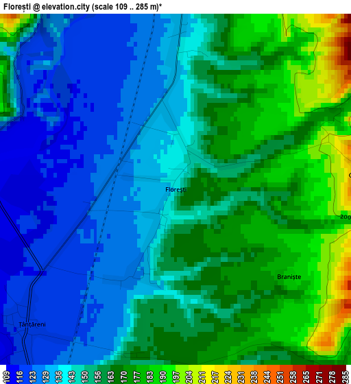
Below is the Elevation map of Florești, which displays elevation range with different colors. Scale of the first map is from 109 to 285 m (358 to 935 ft) with average elevation of 152.6 meters (=501 ft) [note 1]
These maps also provides idea of topography and contour of this city, they are displayed at different zoom levels. More info about maps, scale and edge coordinates you can find below images.
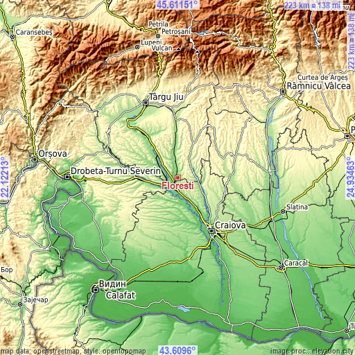
| \ | Map #1 | Topo.Map |
| Scale [m] | 109..285 m | × |
| Scale [ft] | 358..935 ft | × |
| Average | 152.6 m = 501 ft | × |
| Width | 6.96 km = 4.3 mi | 222.6 km = 138.3 mi |
| Height | 6.96 km = 4.3 mi | 222.6 km = 138.3 mi |
| ↑Max Latitude | 44.650451° | 45.61151° |
| Latitude at center | 44.61918° | 44.61918° |
| ↓Min Latitude | 44.587892° | 43.6096° |
| ← Min Longitude | 23.484435° | 22.12213° |
| Longitude center | 23.52838° | 23.52838° |
| →Max Longitude | 23.572325° | 24.93463° |
Nearby cities:
Cities around Florești sort by population:
• Filiaşi elevation 106 m
7.7 km,  186°
186°
• Turburea 150 m
10.9 km,  355°
355°
• Braloştiţa 139 m
13.3 km,  184°
184°
• Stoina 188 m
10.9 km,  49°
49°
• Brăneşti 171 m
6 km,  305°
305°
• Ioneşti 124 m
7.5 km,  267°
267°
• Fratoștița 174 m
4.9 km,  137°
137°
• Poiana 146 m
3.6 km,  3°
3°
• Bâlta 105 m
10.4 km,  206°
206°
• Răcarii de Sus 137 m
9.6 km,  166°
166°
• Crușeț 166 m
11.1 km,  81°
81°
• Ţânţăreni 110 m
4.2 km,  239°
239°
Multilingual:
 En español:
Florești elevación 142 m.
 En France:
Florești élévation 142 m.
 Auf Deutsch:
Florești höhe über dem Meeresspiegel ist 142 m.

Sources and notes:
- [note 1] Map square and city borders are not equal. Map elevation data is calculated only from area inside that square.
- [src 1] Elevation data from geonames database provided with same terms of usage.
- [src 2] The elevation map of Florești is generated using elevation data from NASA's 3 arcsec (90m) resolution SRTM data.
- [src 3] Base (background) map © OpenStreetMap contributors tiles are generated by Geofabrik and OpenTopoMap.
Copyright & License:
This Florești Elevation Map is licensed under CC BY-SA. You may reuse any part from this page, if you give a proper credit by linking to this URL:
 More info on terms of use page.