Braloştiţa elevation
Braloştiţa (Dolj, Comuna Braloştiţa), Romania elevation is 139 meters and Braloştiţa elevation in feet is 456 ft above sea level [src 1]. Braloştiţa is a seat of a second-order administrative division (feature code) with elevation that is 113 meters (371 ft) smaller than average city elevation in Romania.
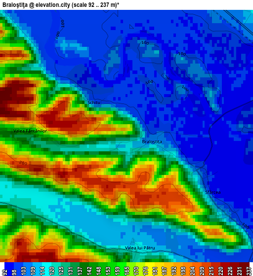
Below is the Elevation map of Braloştiţa, which displays elevation range with different colors. Scale of the first map is from 92 to 237 m (302 to 778 ft) with average elevation of 132.1 meters (=433 ft) [note 1]
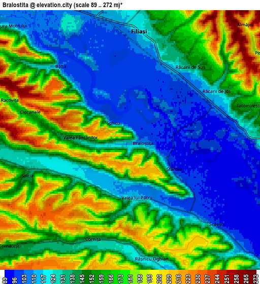
These maps also provides idea of topography and contour of this city, they are displayed at different zoom levels. More info about maps, scale and edge coordinates you can find below images.
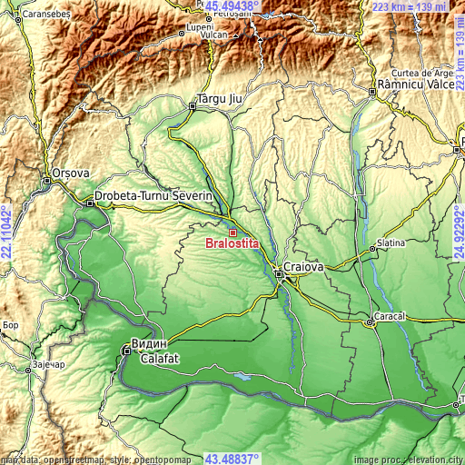
| \ | Map #1 | Map #2 | Topo.Map |
| Scale [m] | 92..237 m | 89..272 m | × |
| Scale [ft] | 302..778 ft | 292..892 ft | × |
| Average | 132.1 m = 433 ft | 149.3 m = 490 ft | × |
| Width | 6.97 km = 4.3 mi | 13.94 km = 8.7 mi | 223 km = 138.6 mi |
| Height | 6.97 km = 4.3 mi | 13.94 km = 8.7 mi | 223 km = 138.6 mi |
| ↑Max Latitude | 44.531336° | 44.562654° | 45.49438° |
| Latitude at center | 44.5° | 44.5° | 44.5° |
| ↓Min Latitude | 44.468648° | 44.437278° | 43.48837° |
| ← Min Longitude | 23.472725° | 23.428779° | 22.11042° |
| Longitude center | 23.51667° | 23.51667° | 23.51667° |
| →Max Longitude | 23.560615° | 23.604561° | 24.92292° |
Nearby cities:
Cities around Braloştiţa sort by population:
• Filiaşi elevation 106 m
5.6 km,  0°
0°
• Brădeşti 126 m
9.4 km,  101°
101°
• Coţofenii din Dos 103 m
10.9 km,  133°
133°
• Fratoștița 174 m
10.5 km,  23°
23°
• Scăeşti 93 m
6.5 km, 125°
• Cernăteşti 169 m
8.6 km,  229°
229°
• Salcia 142 m
5.9 km,  250°
250°
• Bâlta 105 m
5.4 km,  317°
317°
• Răcarii de Sus 137 m
5.1 km,  39°
39°
• Sfârcea 95 m
2.8 km,  123°
123°
• Sopot 191 m
9.4 km,  188°
188°
• Ţânţăreni 110 m
11.4 km,  346°
346°
Multilingual:
 En español:
Braloştiţa elevación 139 m.
 En France:
Braloştiţa élévation 139 m.
 Auf Deutsch:
Braloştiţa höhe über dem Meeresspiegel ist 139 m.

Sources and notes:
- [note 1] Map square and city borders are not equal. Map elevation data is calculated only from area inside that square.
- [src 1] Elevation data from geonames database provided with same terms of usage.
- [src 2] The elevation map of Braloştiţa is generated using elevation data from NASA's 3 arcsec (90m) resolution SRTM data.
- [src 3] Base (background) map © OpenStreetMap contributors tiles are generated by Geofabrik and OpenTopoMap.
Copyright & License:
This Braloştiţa Elevation Map is licensed under CC BY-SA. You may reuse any part from this page, if you give a proper credit by linking to this URL:
 More info on terms of use page.