Frumuşani elevation
Frumuşani (Călăraşi, Comuna Frumuşani), Romania elevation is 50 meters and Frumuşani elevation in feet is 164 ft above sea level [src 1]. Frumuşani is a seat of a second-order administrative division (feature code) with elevation that is 202 meters (663 ft) smaller than average city elevation in Romania.
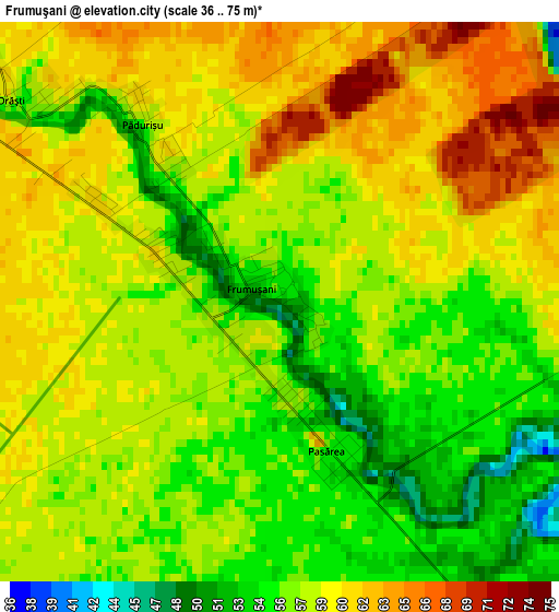
Below is the Elevation map of Frumuşani, which displays elevation range with different colors. Scale of the first map is from 36 to 75 m (118 to 246 ft) with average elevation of 57.6 meters (=189 ft) [note 1]
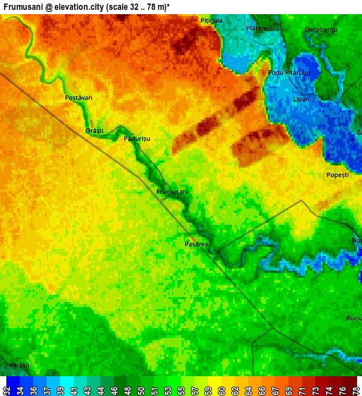
These maps also provides idea of topography and contour of this city, they are displayed at different zoom levels. More info about maps, scale and edge coordinates you can find below images.
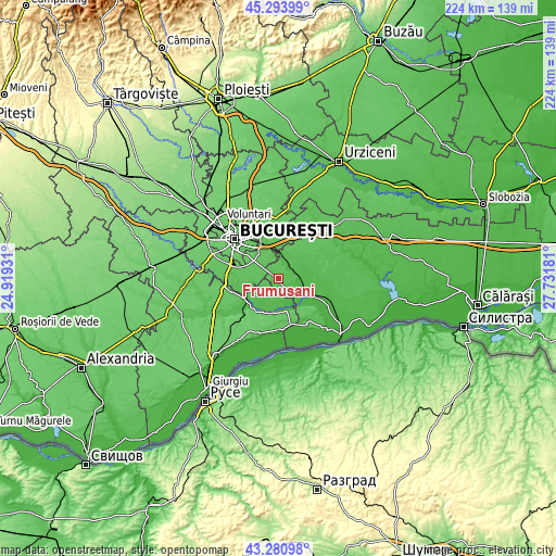
| \ | Map #1 | Map #2 | Topo.Map |
| Scale [m] | 36..75 m | 32..78 m | × |
| Scale [ft] | 118..246 ft | 105..256 ft | × |
| Average | 57.6 m = 189 ft | 56.4 m = 185 ft | × |
| Width | 6.99 km = 4.3 mi | 13.99 km = 8.7 mi | 223.8 km = 139.1 mi |
| Height | 6.99 km = 4.3 mi | 13.99 km = 8.7 mi | 223.8 km = 139.1 mi |
| ↑Max Latitude | 44.327555° | 44.358983° | 45.29399° |
| Latitude at center | 44.29611° | 44.29611° | 44.29611° |
| ↓Min Latitude | 44.264648° | 44.233169° | 43.28098° |
| ← Min Longitude | 26.281615° | 26.237669° | 24.91931° |
| Longitude center | 26.32556° | 26.32556° | 26.32556° |
| →Max Longitude | 26.369505° | 26.413451° | 27.73181° |
Nearby cities:
Cities around Frumuşani sort by population:
• Vasilaţi elevation 43 m
9.7 km,  95°
95°
• Glina 67 m
11.4 km,  328°
328°
• Vărăşti 51 m
8.9 km,  223°
223°
• Fundeni 54 m
9.9 km,  11°
11°
• Plătăreşti 40 m
6.8 km,  28°
28°
• Berceni 65 m
11.3 km,  280°
280°
• Valea Dragului 47 m
9.5 km,  190°
190°
• Gălbinași 44 m
7.8 km,  72°
72°
• Dobreni 53 m
10.1 km,  242°
242°
• Bălăceanca 66 m
11.1 km,  345°
345°
• Herăști 47 m
9.8 km,  164°
164°
• Dorobanțu 53 m
8.4 km,  39°
39°
Multilingual:
 En español:
Frumuşani elevación 50 m.
 En France:
Frumuşani élévation 50 m.
 Auf Deutsch:
Frumuşani höhe über dem Meeresspiegel ist 50 m.

Sources and notes:
- [note 1] Map square and city borders are not equal. Map elevation data is calculated only from area inside that square.
- [src 1] Elevation data from geonames database provided with same terms of usage.
- [src 2] The elevation map of Frumuşani is generated using elevation data from NASA's 3 arcsec (90m) resolution SRTM data.
- [src 3] Base (background) map © OpenStreetMap contributors tiles are generated by Geofabrik and OpenTopoMap.
Copyright & License:
This Frumuşani Elevation Map is licensed under CC BY-SA. You may reuse any part from this page, if you give a proper credit by linking to this URL:
 More info on terms of use page.