Horleşti elevation
Horleşti (Iaşi, Comuna Horleşti), Romania elevation is 115 meters and Horleşti elevation in feet is 377 ft above sea level [src 1]. Horleşti is a seat of a second-order administrative division (feature code) with elevation that is 137 meters (449 ft) smaller than average city elevation in Romania.
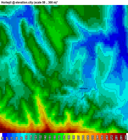
Below is the Elevation map of Horleşti, which displays elevation range with different colors. Scale of the first map is from 58 to 300 m (190 to 984 ft) with average elevation of 125.9 meters (=413 ft) [note 1]
These maps also provides idea of topography and contour of this city, they are displayed at different zoom levels. More info about maps, scale and edge coordinates you can find below images.
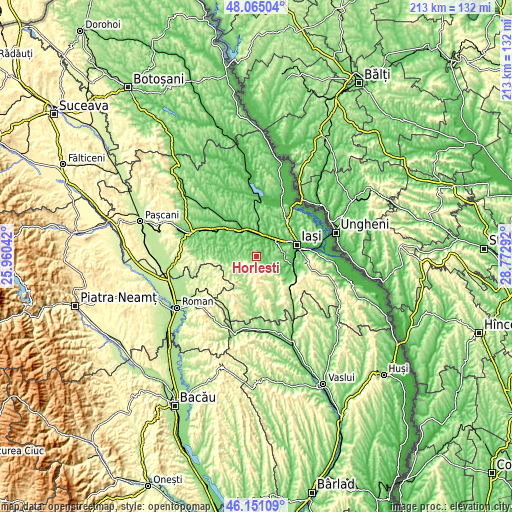
| \ | Map #1 | Topo.Map |
| Scale [m] | 58..300 m | × |
| Scale [ft] | 190..984 ft | × |
| Average | 125.9 m = 413 ft | × |
| Width | 6.65 km = 4.1 mi | 212.8 km = 132.2 mi |
| Height | 6.65 km = 4.1 mi | 212.8 km = 132.2 mi |
| ↑Max Latitude | 47.146567° | 48.06504° |
| Latitude at center | 47.11667° | 47.11667° |
| ↓Min Latitude | 47.086756° | 46.15109° |
| ← Min Longitude | 27.322725° | 25.96042° |
| Longitude center | 27.36667° | 27.36667° |
| →Max Longitude | 27.410615° | 28.77292° |
Nearby cities:
Cities around Horleşti sort by population:
• Podu Iloaiei elevation 84 m
13.4 km,  325°
325°
• Miroslava 128 m
11.9 km,  71°
71°
• Leţcani 46 m
8.3 km,  27°
27°
• Voineşti 191 m
6.7 km,  145°
145°
• Dumeşti 120 m
7.5 km,  350°
350°
• Popeşti 161 m
10.7 km,  290°
290°
• Valea Lupului 91 m
12.2 km,  55°
55°
• Cogeasca 87 m
5.7 km,  14°
14°
• Păușești 108 m
5.5 km, 326°
• Slobozia 250 m
7.5 km, 151°
• Domnița 266 m
10.9 km,  192°
192°
• Mădârjac 190 m
10.9 km,  226°
226°
Multilingual:
 En español:
Horleşti elevación 115 m.
 En France:
Horleşti élévation 115 m.
 Auf Deutsch:
Horleşti höhe über dem Meeresspiegel ist 115 m.

Sources and notes:
- [note 1] Map square and city borders are not equal. Map elevation data is calculated only from area inside that square.
- [src 1] Elevation data from geonames database provided with same terms of usage.
- [src 2] The elevation map of Horleşti is generated using elevation data from NASA's 3 arcsec (90m) resolution SRTM data.
- [src 3] Base (background) map © OpenStreetMap contributors tiles are generated by Geofabrik and OpenTopoMap.
Copyright & License:
This Horleşti Elevation Map is licensed under CC BY-SA. You may reuse any part from this page, if you give a proper credit by linking to this URL:
 More info on terms of use page.