Păușești elevation
Păușești (Iaşi, Comuna Dumeşti), Romania elevation is 108 meters and Păușești elevation in feet is 354 ft above sea level [src 1]. Păușești is a populated place (feature code) with elevation that is 144 meters (472 ft) smaller than average city elevation in Romania.
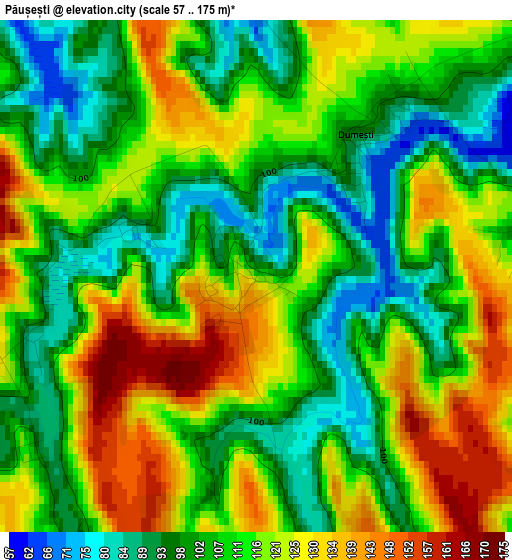
Below is the Elevation map of Păușești, which displays elevation range with different colors. Scale of the first map is from 57 to 175 m (187 to 574 ft) with average elevation of 112 meters (=367 ft) [note 1]
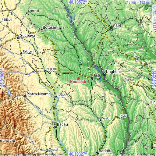
These maps also provides idea of topography and contour of this city, they are displayed at different zoom levels. More info about maps, scale and edge coordinates you can find below images.
| \ | Map #1 | Topo.Map |
| Scale [m] | 57..175 m | × |
| Scale [ft] | 187..574 ft | × |
| Average | 112 m = 367 ft | × |
| Width | 6.65 km = 4.1 mi | 212.6 km = 132.1 mi |
| Height | 6.65 km = 4.1 mi | 212.6 km = 132.1 mi |
| ↑Max Latitude | 47.187973° | 48.10572° |
| Latitude at center | 47.1581° | 47.1581° |
| ↓Min Latitude | 47.12821° | 46.19327° |
| ← Min Longitude | 27.281995° | 25.91969° |
| Longitude center | 27.32594° | 27.32594° |
| →Max Longitude | 27.369885° | 28.73219° |
Nearby cities:
Cities around Păușești sort by population:
• Podu Iloaiei elevation 84 m
7.9 km,  325°
325°
• Leţcani 46 m
7.4 km,  67°
67°
• Dumeşti 120 m
3.3 km,  32°
32°
• Sineşti 161 m
11.7 km,  246°
246°
• Popeşti 161 m
7.1 km,  262°
262°
• Horleşti 115 m
5.5 km,  146°
146°
• Cogeasca 87 m
4.6 km,  78°
78°
• Totoești 71 m
10.7 km,  344°
344°
• Crucea 135 m
11.7 km,  274°
274°
• Zmeu 81 m
11.7 km,  288°
288°
• Budăi 74 m
10.2 km,  310°
310°
• Stornești 161 m
11.7 km, 246°
Multilingual:
 En español:
Păușești elevación 108 m.
 En France:
Păușești élévation 108 m.
 Auf Deutsch:
Păușești höhe über dem Meeresspiegel ist 108 m.

Sources and notes:
- [note 1] Map square and city borders are not equal. Map elevation data is calculated only from area inside that square.
- [src 1] Elevation data from geonames database provided with same terms of usage.
- [src 2] The elevation map of Păușești is generated using elevation data from NASA's 3 arcsec (90m) resolution SRTM data.
- [src 3] Base (background) map © OpenStreetMap contributors tiles are generated by Geofabrik and OpenTopoMap.
Copyright & License:
This Păușești Elevation Map is licensed under CC BY-SA. You may reuse any part from this page, if you give a proper credit by linking to this URL:
 More info on terms of use page.