Ipatele elevation
Ipatele (Iaşi, Comuna Ipatele), Romania elevation is 214 meters and Ipatele elevation in feet is 702 ft above sea level [src 1]. Ipatele is a seat of a second-order administrative division (feature code) with elevation that is 38 meters (125 ft) smaller than average city elevation in Romania.
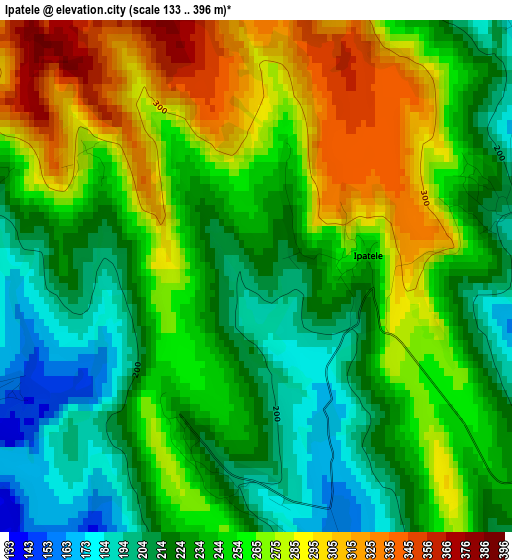
Below is the Elevation map of Ipatele, which displays elevation range with different colors. Scale of the first map is from 133 to 396 m (436 to 1299 ft) with average elevation of 248.2 meters (=814 ft) [note 1]
These maps also provides idea of topography and contour of this city, they are displayed at different zoom levels. More info about maps, scale and edge coordinates you can find below images.
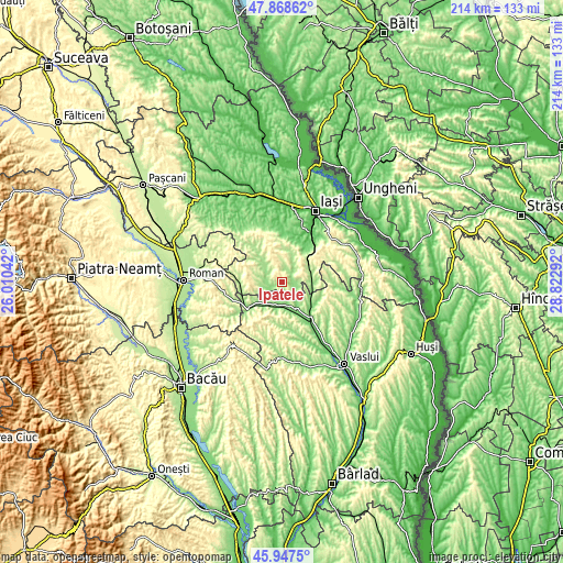
| \ | Map #1 | Topo.Map |
| Scale [m] | 133..396 m | × |
| Scale [ft] | 436..1299 ft | × |
| Average | 248.2 m = 814 ft | × |
| Width | 6.68 km = 4.2 mi | 213.6 km = 132.7 mi |
| Height | 6.68 km = 4.2 mi | 213.6 km = 132.7 mi |
| ↑Max Latitude | 46.946679° | 47.86862° |
| Latitude at center | 46.91667° | 46.91667° |
| ↓Min Latitude | 46.886644° | 45.9475° |
| ← Min Longitude | 27.372725° | 26.01042° |
| Longitude center | 27.41667° | 27.41667° |
| →Max Longitude | 27.460615° | 28.82292° |
Nearby cities:
Cities around Ipatele sort by population:
• Negreşti elevation 119 m
9.4 km,  172°
172°
• Ţibăneşti 150 m
6.3 km,  270°
270°
• Ţibana 162 m
9.7 km,  319°
319°
• Todireşti 183 m
8.3 km,  207°
207°
• Şcheia 257 m
7.8 km,  76°
76°
• Mironeasa 271 m
5.6 km,  0°
0°
• Scânteia 148 m
11.4 km,  90°
90°
• Rebricea 188 m
11.6 km,  118°
118°
• Grajduri 306 m
9.4 km,  53°
53°
• Gârbești 217 m
11.5 km,  309°
309°
• Glodenii Gândului 218 m
9.7 km,  293°
293°
• Drăgușeni 164 m
7.5 km,  103°
103°
Multilingual:
 En español:
Ipatele elevación 214 m.
 En France:
Ipatele élévation 214 m.


Sources and notes:
- [note 1] Map square and city borders are not equal. Map elevation data is calculated only from area inside that square.
- [src 1] Elevation data from geonames database provided with same terms of usage.
- [src 2] The elevation map of Ipatele is generated using elevation data from NASA's 3 arcsec (90m) resolution SRTM data.
- [src 3] Base (background) map © OpenStreetMap contributors tiles are generated by Geofabrik and OpenTopoMap.
Copyright & License:
This Ipatele Elevation Map is licensed under CC BY-SA. You may reuse any part from this page, if you give a proper credit by linking to this URL:
 More info on terms of use page.