Minieri elevation
Minieri (Prahova, Comuna Filipeştii de Pădure), Romania elevation is 286 meters and Minieri elevation in feet is 938 ft above sea level [src 1]. Minieri is a populated place (feature code) with elevation that is 34 meters (112 ft) bigger than average city elevation in Romania.
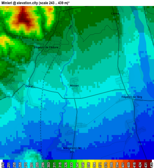
Below is the Elevation map of Minieri, which displays elevation range with different colors. Scale of the first map is from 243 to 439 m (797 to 1440 ft) with average elevation of 284.1 meters (=932 ft) [note 1]
These maps also provides idea of topography and contour of this city, they are displayed at different zoom levels. More info about maps, scale and edge coordinates you can find below images.
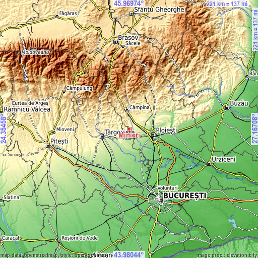
| \ | Map #1 | Topo.Map |
| Scale [m] | 243..439 m | × |
| Scale [ft] | 797..1440 ft | × |
| Average | 284.1 m = 932 ft | × |
| Width | 6.91 km = 4.3 mi | 221.2 km = 137.4 mi |
| Height | 6.91 km = 4.3 mi | 221.2 km = 137.4 mi |
| ↑Max Latitude | 45.014794° | 45.96974° |
| Latitude at center | 44.98372° | 44.98372° |
| ↓Min Latitude | 44.952629° | 43.98044° |
| ← Min Longitude | 25.716885° | 24.35458° |
| Longitude center | 25.76083° | 25.76083° |
| →Max Longitude | 25.804775° | 27.16708° |
Nearby cities:
Cities around Minieri sort by population:
• Filipeştii de Pădure elevation 301 m
2 km,  334°
334°
• Ariceştii-Rahtivani 238 m
6.8 km,  123°
123°
• Dărmăneşti 222 m
7.7 km,  166°
166°
• Filipeştii de Târg 278 m
1.8 km,  91°
91°
• Floreşti 333 m
7.6 km,  13°
13°
• Dițești 288 m
2.7 km,  261°
261°
• Mărginenii de Jos 261 m
2.7 km,  181°
181°
• Ghirdoveni 240 m
8.4 km,  235°
235°
• Nedelea 260 m
4.6 km,  106°
106°
• Cătina 300 m
3.4 km,  32°
32°
• Mărginenii de Sus 237 m
5.8 km,  186°
186°
• Lunca Prahovei 332 m
7.1 km, 6°
Multilingual:
 En español:
Minieri elevación 286 m.
 En France:
Minieri élévation 286 m.


Sources and notes:
- [note 1] Map square and city borders are not equal. Map elevation data is calculated only from area inside that square.
- [src 1] Elevation data from geonames database provided with same terms of usage.
- [src 2] The elevation map of Minieri is generated using elevation data from NASA's 3 arcsec (90m) resolution SRTM data.
- [src 3] Base (background) map © OpenStreetMap contributors tiles are generated by Geofabrik and OpenTopoMap.
Copyright & License:
This Minieri Elevation Map is licensed under CC BY-SA. You may reuse any part from this page, if you give a proper credit by linking to this URL:
 More info on terms of use page.