Ghirdoveni elevation
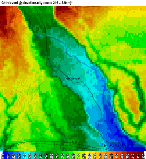
Ghirdoveni (Dâmboviţa, Comuna I. L. Caragiale), Romania elevation is 240 meters and Ghirdoveni elevation in feet is 787 ft above sea level [src 1]. Ghirdoveni is a seat of a second-order administrative division (feature code) with elevation that is 12 meters (39 ft) smaller than average city elevation in Romania.
Below is the Elevation map of Ghirdoveni, which displays elevation range with different colors. Scale of the first map is from 216 to 320 m (709 to 1050 ft) with average elevation of 262.9 meters (=863 ft) [note 1]
These maps also provides idea of topography and contour of this city, they are displayed at different zoom levels. More info about maps, scale and edge coordinates you can find below images.
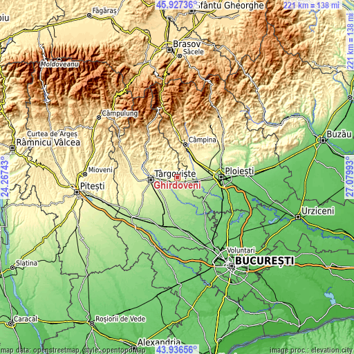
| \ | Map #1 | Topo.Map |
| Scale [m] | 216..320 m | × |
| Scale [ft] | 709..1050 ft | × |
| Average | 262.9 m = 863 ft | × |
| Width | 6.92 km = 4.3 mi | 221.4 km = 137.6 mi |
| Height | 6.92 km = 4.3 mi | 221.3 km = 137.5 mi |
| ↑Max Latitude | 44.971688° | 45.92736° |
| Latitude at center | 44.94059° | 44.94059° |
| ↓Min Latitude | 44.909475° | 43.93656° |
| ← Min Longitude | 25.629735° | 24.26743° |
| Longitude center | 25.67368° | 25.67368° |
| →Max Longitude | 25.717625° | 27.07993° |
Nearby cities:
Cities around Ghirdoveni sort by population:
• Moreni elevation 264 m
5.3 km,  333°
333°
• Filipeştii de Pădure 301 m
8.9 km,  42°
42°
• Bucşani 204 m
8.4 km,  192°
192°
• Dițești 288 m
6 km, 43°
• I. L. Caragiale 221 m
4.1 km,  146°
146°
• Mărginenii de Jos 261 m
7.1 km,  73°
73°
• Gura Ocniței 258 m
8.3 km,  270°
270°
• Mija 255 m
3 km,  176°
176°
• Adânca 235 m
5.4 km,  248°
248°
• Săcueni 237 m
8.6 km, 247°
• Minieri 286 m
8.4 km,  55°
55°
• Mărginenii de Sus 237 m
6.3 km,  99°
99°
Multilingual:
 En español:
Ghirdoveni elevación 240 m.
 En France:
Ghirdoveni élévation 240 m.
 Auf Deutsch:
Ghirdoveni höhe über dem Meeresspiegel ist 240 m.

Sources and notes:
- [note 1] Map square and city borders are not equal. Map elevation data is calculated only from area inside that square.
- [src 1] Elevation data from geonames database provided with same terms of usage.
- [src 2] The elevation map of Ghirdoveni is generated using elevation data from NASA's 3 arcsec (90m) resolution SRTM data.
- [src 3] Base (background) map © OpenStreetMap contributors tiles are generated by Geofabrik and OpenTopoMap.
Copyright & License:
This Ghirdoveni Elevation Map is licensed under CC BY-SA. You may reuse any part from this page, if you give a proper credit by linking to this URL:
 More info on terms of use page.