Miron Costin elevation
Miron Costin (Neamţ, Comuna Trifeşti), Romania elevation is 243 meters and Miron Costin elevation in feet is 797 ft above sea level [src 1]. Miron Costin is a populated place (feature code) with elevation that is 9 meters (30 ft) smaller than average city elevation in Romania.
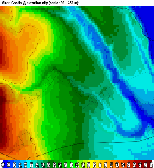
Below is the Elevation map of Miron Costin, which displays elevation range with different colors. Scale of the first map is from 192 to 359 m (630 to 1178 ft) with average elevation of 255 meters (=837 ft) [note 1]
These maps also provides idea of topography and contour of this city, they are displayed at different zoom levels. More info about maps, scale and edge coordinates you can find below images.
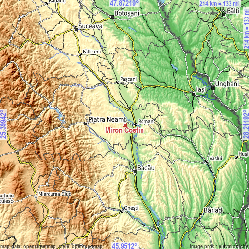
| \ | Map #1 | Topo.Map |
| Scale [m] | 192..359 m | × |
| Scale [ft] | 630..1178 ft | × |
| Average | 255 m = 837 ft | × |
| Width | 6.67 km = 4.1 mi | 213.6 km = 132.7 mi |
| Height | 6.67 km = 4.1 mi | 213.6 km = 132.7 mi |
| ↑Max Latitude | 46.950307° | 47.87219° |
| Latitude at center | 46.9203° | 46.9203° |
| ↓Min Latitude | 46.890276° | 45.9512° |
| ← Min Longitude | 26.761725° | 25.39942° |
| Longitude center | 26.80567° | 26.80567° |
| →Max Longitude | 26.849615° | 28.21192° |
Nearby cities:
Cities around Miron Costin sort by population:
• Roman elevation 202 m
9.2 km,  89°
89°
• Cordun 189 m
5.7 km,  54°
54°
• Gherăeşti 210 m
10.7 km,  4°
4°
• Trifeşti 235 m
0.9 km,  115°
115°
• Dulceşti 233 m
5.9 km,  330°
330°
• Pildești 206 m
8.6 km,  10°
10°
• Horia 186 m
8.7 km,  99°
99°
• Moldoveni 283 m
10.1 km,  197°
197°
• Făurei 426 m
9.3 km,  267°
267°
• Ruginoasa 317 m
10.5 km,  314°
314°
• Budești 264 m
7.5 km,  287°
287°
• Secuieni 223 m
8.1 km,  164°
164°
Multilingual:
 En español:
Miron Costin elevación 243 m.
 En France:
Miron Costin élévation 243 m.
 Auf Deutsch:
Miron Costin höhe über dem Meeresspiegel ist 243 m.

Sources and notes:
- [note 1] Map square and city borders are not equal. Map elevation data is calculated only from area inside that square.
- [src 1] Elevation data from geonames database provided with same terms of usage.
- [src 2] The elevation map of Miron Costin is generated using elevation data from NASA's 3 arcsec (90m) resolution SRTM data.
- [src 3] Base (background) map © OpenStreetMap contributors tiles are generated by Geofabrik and OpenTopoMap.
Copyright & License:
This Miron Costin Elevation Map is licensed under CC BY-SA. You may reuse any part from this page, if you give a proper credit by linking to this URL:
 More info on terms of use page.