Roman elevation
Roman (Neamţ, Municipiul Roman), Romania elevation is 202 meters and Roman elevation in feet is 663 ft above sea level [src 1]. Roman is a seat of a second-order administrative division (feature code) with elevation that is 50 meters (164 ft) smaller than average city elevation in Romania.
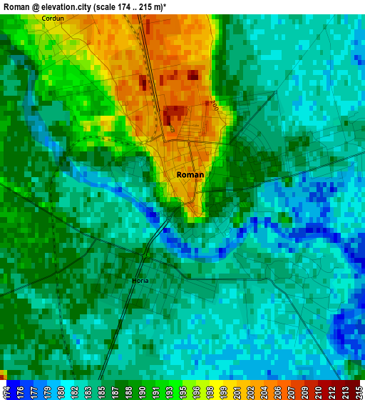
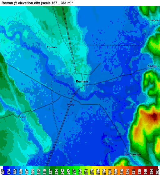
Below is the Elevation map of Roman, which displays elevation range with different colors. Scale of the first map is from 174 to 215 m (571 to 705 ft) with average elevation of 187 meters (=614 ft) [note 1]
These maps also provides idea of topography and contour of this city, they are displayed at different zoom levels. More info about maps, scale and edge coordinates you can find below images.
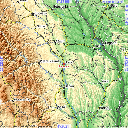
| \ | Map #1 | Map #2 | Topo.Map |
| Scale [m] | 174..215 m | 167..361 m | × |
| Scale [ft] | 571..705 ft | 548..1184 ft | × |
| Average | 187 m = 614 ft | 197.7 m = 649 ft | × |
| Width | 6.67 km = 4.1 mi | 13.35 km = 8.3 mi | 213.6 km = 132.7 mi |
| Height | 6.67 km = 4.1 mi | 13.35 km = 8.3 mi | 213.6 km = 132.7 mi |
| ↑Max Latitude | 46.951196° | 46.981186° | 47.87306° |
| Latitude at center | 46.92119° | 46.92119° | 46.92119° |
| ↓Min Latitude | 46.891167° | 46.861127° | 45.9521° |
| ← Min Longitude | 26.882515° | 26.838569° | 25.52021° |
| Longitude center | 26.92646° | 26.92646° | 26.92646° |
| →Max Longitude | 26.970405° | 27.014351° | 28.33271° |
Nearby cities:
Cities around Roman sort by population:
• Tămăşeni elevation 186 m
6.9 km,  4°
4°
• Sagna 236 m
9.7 km,  44°
44°
• Cordun 189 m
5.6 km,  305°
305°
• Trifeşti 235 m
8.4 km,  266°
266°
• Adjudeni 187 m
10.5 km,  9°
9°
• Buruienești 186 m
9.2 km,  24°
24°
• Horia 186 m
1.7 km,  199°
199°
• Cotu Vameș 184 m
2.8 km,  127°
127°
• Ion Creangă 187 m
7 km,  144°
144°
• Miron Costin 243 m
9.2 km, 269°
• Traian 228 m
8 km,  347°
347°
• Gâdinţi 198 m
7 km,  78°
78°
Multilingual:
 En español:
Roman elevación 202 m.
 En France:
Roman élévation 202 m.


Sources and notes:
- [note 1] Map square and city borders are not equal. Map elevation data is calculated only from area inside that square.
- [src 1] Elevation data from geonames database provided with same terms of usage.
- [src 2] The elevation map of Roman is generated using elevation data from NASA's 3 arcsec (90m) resolution SRTM data.
- [src 3] Base (background) map © OpenStreetMap contributors tiles are generated by Geofabrik and OpenTopoMap.
Copyright & License:
This Roman Elevation Map is licensed under CC BY-SA. You may reuse any part from this page, if you give a proper credit by linking to this URL:
 More info on terms of use page.