Mitoc elevation
Mitoc (Botoşani, Comuna Mitoc), Romania elevation is 90 meters and Mitoc elevation in feet is 295 ft above sea level [src 1]. Mitoc is a seat of a second-order administrative division (feature code) with elevation that is 162 meters (531 ft) smaller than average city elevation in Romania.
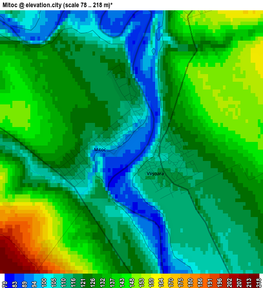
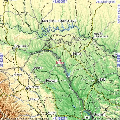
Below is the Elevation map of Mitoc, which displays elevation range with different colors. Scale of the first map is from 78 to 218 m (256 to 715 ft) with average elevation of 125.8 meters (=413 ft) [note 1]
These maps also provides idea of topography and contour of this city, they are displayed at different zoom levels. More info about maps, scale and edge coordinates you can find below images.
| \ | Map #1 | Topo.Map |
| Scale [m] | 78..218 m | × |
| Scale [ft] | 256..715 ft | × |
| Average | 125.8 m = 413 ft | × |
| Width | 6.53 km = 4.1 mi | 208.8 km = 129.7 mi |
| Height | 6.53 km = 4.1 mi | 208.8 km = 129.7 mi |
| ↑Max Latitude | 48.12934° | 49.03057° |
| Latitude at center | 48.1° | 48.1° |
| ↓Min Latitude | 48.070644° | 47.15227° |
| ← Min Longitude | 26.989385° | 25.62708° |
| Longitude center | 27.03333° | 27.03333° |
| →Max Longitude | 27.077275° | 28.43958° |
Nearby cities:
Cities around Mitoc sort by population:
• Săveni elevation 83 m
20.8 km,  216°
216°
• Avrămeni 233 m
11.1 km,  213°
213°
• Coţuşca 189 m
14.1 km,  285°
285°
• Manoleasa 146 m
13.2 km,  169°
169°
• Vlăsineşti 116 m
21.6 km, 211°
• Drăguşeni 143 m
18.6 km,  240°
240°
• Hăneşti 75 m
20.7 km,  190°
190°
• Ripiceni 118 m
18.3 km,  155°
155°
• Miorcani 182 m
17.6 km,  310°
310°
• Sârbi 102 m
19.5 km, 206°
• Adășeni 188 m
7.9 km, 244°
• Rădăuți-Prut 119 m
22.8 km, 310°
Multilingual:
 En español:
Mitoc elevación 90 m.
 En France:
Mitoc élévation 90 m.


Sources and notes:
- [note 1] Map square and city borders are not equal. Map elevation data is calculated only from area inside that square.
- [src 1] Elevation data from geonames database provided with same terms of usage.
- [src 2] The elevation map of Mitoc is generated using elevation data from NASA's 3 arcsec (90m) resolution SRTM data.
- [src 3] Base (background) map © OpenStreetMap contributors tiles are generated by Geofabrik and OpenTopoMap.
Copyright & License:
This Mitoc Elevation Map is licensed under CC BY-SA. You may reuse any part from this page, if you give a proper credit by linking to this URL:
 More info on terms of use page.