Sârbi elevation
Sârbi (Botoşani, Comuna Vlăsineşti), Romania elevation is 102 meters and Sârbi elevation in feet is 335 ft above sea level [src 1]. Sârbi is a populated place (feature code) with elevation that is 150 meters (492 ft) smaller than average city elevation in Romania.
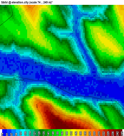
Below is the Elevation map of Sârbi, which displays elevation range with different colors. Scale of the first map is from 74 to 249 m (243 to 817 ft) with average elevation of 132.1 meters (=433 ft) [note 1]
These maps also provides idea of topography and contour of this city, they are displayed at different zoom levels. More info about maps, scale and edge coordinates you can find below images.
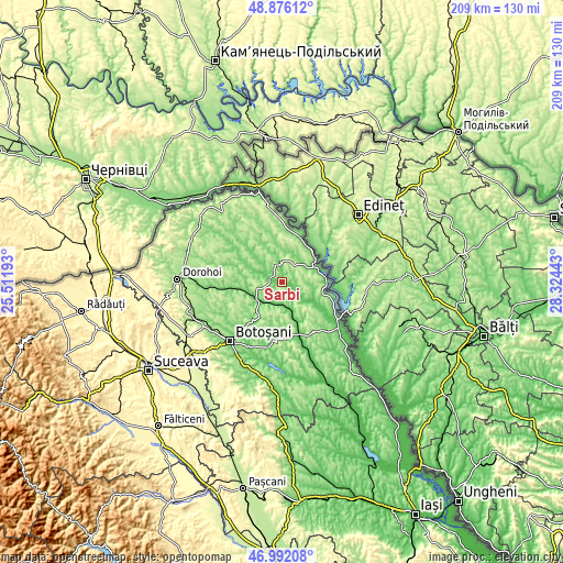
| \ | Map #1 | Topo.Map |
| Scale [m] | 74..249 m | × |
| Scale [ft] | 243..817 ft | × |
| Average | 132.1 m = 433 ft | × |
| Width | 6.55 km = 4.1 mi | 209.5 km = 130.2 mi |
| Height | 6.55 km = 4.1 mi | 209.5 km = 130.2 mi |
| ↑Max Latitude | 47.972109° | 48.87612° |
| Latitude at center | 47.94268° | 47.94268° |
| ↓Min Latitude | 47.913234° | 46.99208° |
| ← Min Longitude | 26.874235° | 25.51193° |
| Longitude center | 26.91818° | 26.91818° |
| →Max Longitude | 26.962125° | 28.32443° |
Nearby cities:
Cities around Sârbi sort by population:
• Săveni elevation 83 m
3.9 km,  281°
281°
• Ungureni-Jianu 110 m
12 km,  236°
236°
• Avrămeni 233 m
8.6 km,  16°
16°
• Manoleasa 146 m
11.9 km,  67°
67°
• Vlăsineşti 116 m
2.8 km,  248°
248°
• Dângeni 85 m
10.9 km,  160°
160°
• Ştiubieni 106 m
10.4 km, 284°
• Drăguşeni 143 m
11.2 km,  317°
317°
• Mihălăşeni 90 m
12.9 km,  120°
120°
• Ungureni 99 m
11.2 km,  232°
232°
• Hăneşti 75 m
5.7 km, 120°
• Iacobeni 94 m
9.1 km,  182°
182°
Multilingual:
 En español:
Sârbi elevación 102 m.
 En France:
Sârbi élévation 102 m.


Sources and notes:
- [note 1] Map square and city borders are not equal. Map elevation data is calculated only from area inside that square.
- [src 1] Elevation data from geonames database provided with same terms of usage.
- [src 2] The elevation map of Sârbi is generated using elevation data from NASA's 3 arcsec (90m) resolution SRTM data.
- [src 3] Base (background) map © OpenStreetMap contributors tiles are generated by Geofabrik and OpenTopoMap.
Copyright & License:
This Sârbi Elevation Map is licensed under CC BY-SA. You may reuse any part from this page, if you give a proper credit by linking to this URL:
 More info on terms of use page.