Nepos elevation
Nepos (Bistriţa-Năsăud, Comuna Feldru), Romania elevation is 359 meters and Nepos elevation in feet is 1178 ft above sea level [src 1]. Nepos is a populated place (feature code) with elevation that is 107 meters (351 ft) bigger than average city elevation in Romania.
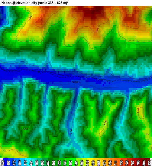
Below is the Elevation map of Nepos, which displays elevation range with different colors. Scale of the first map is from 338 to 823 m (1109 to 2700 ft) with average elevation of 509.7 meters (=1672 ft) [note 1]
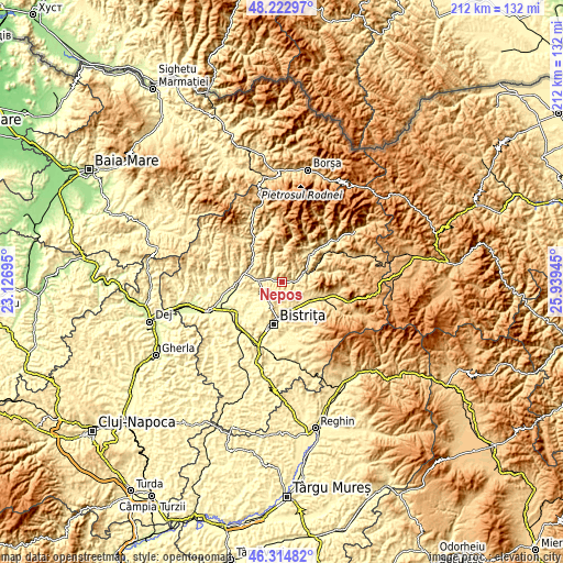
These maps also provides idea of topography and contour of this city, they are displayed at different zoom levels. More info about maps, scale and edge coordinates you can find below images.
| \ | Map #1 | Topo.Map |
| Scale [m] | 338..823 m | × |
| Scale [ft] | 1109..2700 ft | × |
| Average | 509.7 m = 1672 ft | × |
| Width | 6.63 km = 4.1 mi | 212.2 km = 131.9 mi |
| Height | 6.63 km = 4.1 mi | 212.2 km = 131.9 mi |
| ↑Max Latitude | 47.307306° | 48.22297° |
| Latitude at center | 47.2775° | 47.2775° |
| ↓Min Latitude | 47.247677° | 46.31482° |
| ← Min Longitude | 24.489255° | 23.12695° |
| Longitude center | 24.5332° | 24.5332° |
| →Max Longitude | 24.577145° | 25.93945° |
Nearby cities:
Cities around Nepos sort by population:
• Năsăud elevation 317 m
10.1 km,  273°
273°
• Feldru 393 m
5.1 km,  82°
82°
• Josenii Bârgăului 467 m
13.2 km,  120°
120°
• Rebrişoara 329 m
6.3 km,  275°
275°
• Dumitra 448 m
7.7 km,  209°
209°
• Salva 300 m
14 km, 280°
• Livezile 408 m
10.8 km,  166°
166°
• Ilva Mică 637 m
11 km,  66°
66°
• Rebra 423 m
5 km,  330°
330°
• Parva 622 m
13.7 km,  5°
5°
• Mijlocenii Bârgăului 474 m
13.6 km, 120°
• Unirea 375 m
13 km,  180°
180°
Multilingual:
 En español:
Nepos elevación 359 m.
 En France:
Nepos élévation 359 m.


Sources and notes:
- [note 1] Map square and city borders are not equal. Map elevation data is calculated only from area inside that square.
- [src 1] Elevation data from geonames database provided with same terms of usage.
- [src 2] The elevation map of Nepos is generated using elevation data from NASA's 3 arcsec (90m) resolution SRTM data.
- [src 3] Base (background) map © OpenStreetMap contributors tiles are generated by Geofabrik and OpenTopoMap.
Copyright & License:
This Nepos Elevation Map is licensed under CC BY-SA. You may reuse any part from this page, if you give a proper credit by linking to this URL:
 More info on terms of use page.