Năsăud elevation
Năsăud (Bistriţa-Năsăud, Oraş Nãsãud), Romania elevation is 317 meters and Năsăud elevation in feet is 1040 ft above sea level [src 1]. Năsăud is a seat of a second-order administrative division (feature code) with elevation that is 65 meters (213 ft) bigger than average city elevation in Romania.
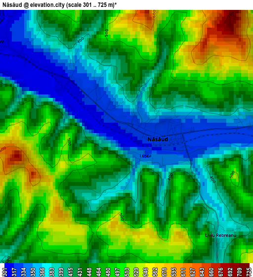
Below is the Elevation map of Năsăud, which displays elevation range with different colors. Scale of the first map is from 301 to 725 m (988 to 2379 ft) with average elevation of 445.1 meters (=1460 ft) [note 1]
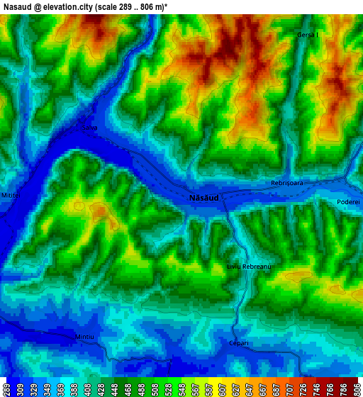
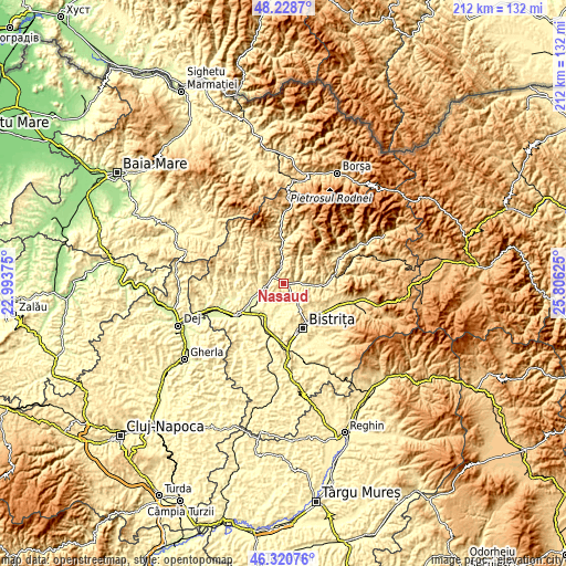
These maps also provides idea of topography and contour of this city, they are displayed at different zoom levels. More info about maps, scale and edge coordinates you can find below images.
| \ | Map #1 | Map #2 | Topo.Map |
| Scale [m] | 301..725 m | 289..806 m | × |
| Scale [ft] | 988..2379 ft | 948..2644 ft | × |
| Average | 445.1 m = 1460 ft | 454 m = 1490 ft | × |
| Width | 6.63 km = 4.1 mi | 13.26 km = 8.2 mi | 212.1 km = 131.8 mi |
| Height | 6.63 km = 4.1 mi | 13.26 km = 8.2 mi | 212.1 km = 131.8 mi |
| ↑Max Latitude | 47.313133° | 47.342919° | 48.2287° |
| Latitude at center | 47.28333° | 47.28333° | 47.28333° |
| ↓Min Latitude | 47.25351° | 47.223674° | 46.32076° |
| ← Min Longitude | 24.356055° | 24.312109° | 22.99375° |
| Longitude center | 24.4° | 24.4° | 24.4° |
| →Max Longitude | 24.443945° | 24.487891° | 25.80625° |
Nearby cities:
Cities around Năsăud sort by population:
• Nimigea de Sus elevation 332 m
6.3 km,  270°
270°
• Rebrişoara 329 m
3.8 km,  90°
90°
• Dumitra 448 m
9.7 km,  139°
139°
• Salva 300 m
4.2 km,  296°
296°
• Şintereag 282 m
13.4 km,  214°
214°
• Zagra 442 m
10.4 km, 302°
• Rebra 423 m
8.4 km,  63°
63°
• Coşbuc 343 m
9.1 km,  355°
355°
• Chiuza 272 m
12.6 km,  243°
243°
• Nepos 359 m
10.1 km, 93°
• Runcu Salvei 405 m
8.8 km,  320°
320°
• Nimigea de Jos 286 m
8.2 km,  246°
246°
Multilingual:
 En español:
Năsăud elevación 317 m.
 En France:
Năsăud élévation 317 m.


Sources and notes:
- [note 1] Map square and city borders are not equal. Map elevation data is calculated only from area inside that square.
- [src 1] Elevation data from geonames database provided with same terms of usage.
- [src 2] The elevation map of Năsăud is generated using elevation data from NASA's 3 arcsec (90m) resolution SRTM data.
- [src 3] Base (background) map © OpenStreetMap contributors tiles are generated by Geofabrik and OpenTopoMap.
Copyright & License:
This Năsăud Elevation Map is licensed under CC BY-SA. You may reuse any part from this page, if you give a proper credit by linking to this URL:
 More info on terms of use page.