Unirea elevation
Unirea (Bistriţa-Năsăud, Municipiul Bistriţa), Romania elevation is 375 meters and Unirea elevation in feet is 1230 ft above sea level [src 1]. Unirea is a section of populated place (feature code) with elevation that is 123 meters (404 ft) bigger than average city elevation in Romania.
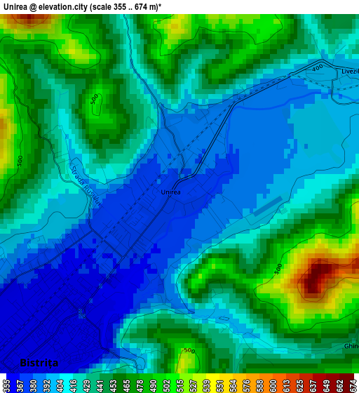
Below is the Elevation map of Unirea, which displays elevation range with different colors. Scale of the first map is from 355 to 674 m (1165 to 2211 ft) with average elevation of 429.4 meters (=1409 ft) [note 1]
These maps also provides idea of topography and contour of this city, they are displayed at different zoom levels. More info about maps, scale and edge coordinates you can find below images.
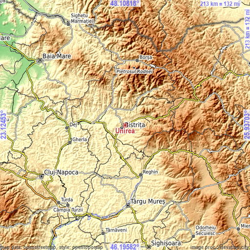
| \ | Map #1 | Topo.Map |
| Scale [m] | 355..674 m | × |
| Scale [ft] | 1165..2211 ft | × |
| Average | 429.4 m = 1409 ft | × |
| Width | 6.64 km = 4.1 mi | 212.6 km = 132.1 mi |
| Height | 6.64 km = 4.1 mi | 212.6 km = 132.1 mi |
| ↑Max Latitude | 47.190472° | 48.10818° |
| Latitude at center | 47.1606° | 47.1606° |
| ↓Min Latitude | 47.130711° | 46.19582° |
| ← Min Longitude | 24.486835° | 23.12453° |
| Longitude center | 24.53078° | 24.53078° |
| →Max Longitude | 24.574725° | 25.93703° |
Nearby cities:
Cities around Unirea sort by population:
• Bistriţa elevation 362 m
3.8 km,  217°
217°
• Feldru 393 m
14.6 km,  20°
20°
• Josenii Bârgăului 467 m
13.1 km,  61°
61°
• Dumitra 448 m
7.2 km,  330°
330°
• Livezile 408 m
3.7 km,  47°
47°
• Şieu-Măgheruş 307 m
14.1 km,  232°
232°
• Budacu de Jos 348 m
8.7 km,  187°
187°
• Nepos 359 m
13 km,  0°
0°
• Mijlocenii Bârgăului 474 m
13.5 km, 62°
• Viișoara 337 m
8.9 km, 223°
• Petriș 409 m
9.5 km,  132°
132°
• Dumitrița 463 m
12.2 km,  144°
144°
Multilingual:
 En español:
Unirea elevación 375 m.
 En France:
Unirea élévation 375 m.


Sources and notes:
- [note 1] Map square and city borders are not equal. Map elevation data is calculated only from area inside that square.
- [src 1] Elevation data from geonames database provided with same terms of usage.
- [src 2] The elevation map of Unirea is generated using elevation data from NASA's 3 arcsec (90m) resolution SRTM data.
- [src 3] Base (background) map © OpenStreetMap contributors tiles are generated by Geofabrik and OpenTopoMap.
Copyright & License:
This Unirea Elevation Map is licensed under CC BY-SA. You may reuse any part from this page, if you give a proper credit by linking to this URL:
 More info on terms of use page.