Nereju Mic elevation
Nereju Mic (Vrancea, Comuna Nereju), Romania elevation is 596 meters and Nereju Mic elevation in feet is 1955 ft above sea level [src 1]. Nereju Mic is a populated place (feature code) with elevation that is 344 meters (1129 ft) bigger than average city elevation in Romania.
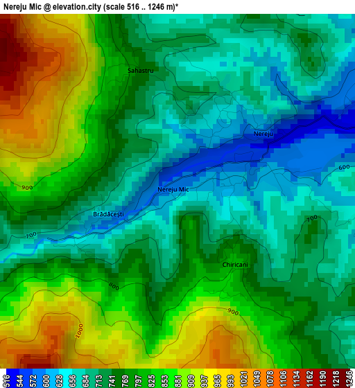
Below is the Elevation map of Nereju Mic, which displays elevation range with different colors. Scale of the first map is from 516 to 1246 m (1693 to 4088 ft) with average elevation of 773.1 meters (=2536 ft) [note 1]
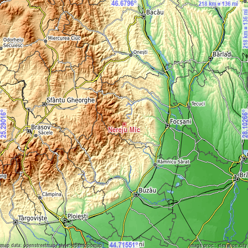
These maps also provides idea of topography and contour of this city, they are displayed at different zoom levels. More info about maps, scale and edge coordinates you can find below images.
| \ | Map #1 | Topo.Map |
| Scale [m] | 516..1246 m | × |
| Scale [ft] | 1693..4088 ft | × |
| Average | 773.1 m = 2536 ft | × |
| Width | 6.82 km = 4.2 mi | 218.4 km = 135.7 mi |
| Height | 6.82 km = 4.2 mi | 218.4 km = 135.7 mi |
| ↑Max Latitude | 45.73686° | 46.6796° |
| Latitude at center | 45.70618° | 45.70618° |
| ↓Min Latitude | 45.675483° | 44.71551° |
| ← Min Longitude | 26.652465° | 25.29016° |
| Longitude center | 26.69641° | 26.69641° |
| →Max Longitude | 26.740355° | 28.10266° |
Nearby cities:
Cities around Nereju Mic sort by population:
• Nereju elevation 603 m
2 km,  53°
53°
• Paltin 493 m
8.7 km,  10°
10°
• Vrâncioaia 488 m
16.2 km, 10°
• Reghiu 584 m
13.7 km, 51°
• Nistoreşti 503 m
14.4 km, 11°
• Vintileasca 658 m
12.1 km,  166°
166°
• Andreiaşu de Jos 454 m
11.7 km,  65°
65°
• Năruja 410 m
15.7 km,  25°
25°
• Jitia 620 m
13.8 km, 173°
• Șindrilari 277 m
17 km,  56°
56°
• Vulcăneasa 251 m
18.2 km, 65°
• Spulber 476 m
7.1 km,  44°
44°
Multilingual:
 En español:
Nereju Mic elevación 596 m.
 En France:
Nereju Mic élévation 596 m.
 Auf Deutsch:
Nereju Mic höhe über dem Meeresspiegel ist 596 m.

Sources and notes:
- [note 1] Map square and city borders are not equal. Map elevation data is calculated only from area inside that square.
- [src 1] Elevation data from geonames database provided with same terms of usage.
- [src 2] The elevation map of Nereju Mic is generated using elevation data from NASA's 3 arcsec (90m) resolution SRTM data.
- [src 3] Base (background) map © OpenStreetMap contributors tiles are generated by Geofabrik and OpenTopoMap.
Copyright & License:
This Nereju Mic Elevation Map is licensed under CC BY-SA. You may reuse any part from this page, if you give a proper credit by linking to this URL:
 More info on terms of use page.