Vulcăneasa elevation
Vulcăneasa (Vrancea, Comuna Mera), Romania elevation is 251 meters and Vulcăneasa elevation in feet is 823 ft above sea level [src 1]. Vulcăneasa is a populated place (feature code) with elevation that is 1 meters (3 ft) smaller than average city elevation in Romania.
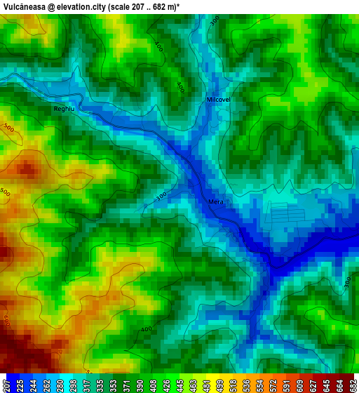
Below is the Elevation map of Vulcăneasa, which displays elevation range with different colors. Scale of the first map is from 207 to 682 m (679 to 2238 ft) with average elevation of 374.2 meters (=1228 ft) [note 1]
These maps also provides idea of topography and contour of this city, they are displayed at different zoom levels. More info about maps, scale and edge coordinates you can find below images.
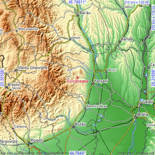
| \ | Map #1 | Topo.Map |
| Scale [m] | 207..682 m | × |
| Scale [ft] | 679..2238 ft | × |
| Average | 374.2 m = 1228 ft | × |
| Width | 6.82 km = 4.2 mi | 218.1 km = 135.5 mi |
| Height | 6.82 km = 4.2 mi | 218.1 km = 135.5 mi |
| ↑Max Latitude | 45.804523° | 46.74611° |
| Latitude at center | 45.77388° | 45.77388° |
| ↓Min Latitude | 45.74322° | 44.7844° |
| ← Min Longitude | 26.865865° | 25.50356° |
| Longitude center | 26.90981° | 26.90981° |
| →Max Longitude | 26.953755° | 28.31606° |
Nearby cities:
Cities around Vulcăneasa sort by population:
• Odobeşti elevation 223 m
10.9 km,  94°
94°
• Boloteşti 148 m
13.8 km,  61°
61°
• Jariştea 153 m
12.2 km, 85°
• Mera 218 m
3.2 km,  104°
104°
• Reghiu 584 m
6 km,  280°
280°
• Broşteni 285 m
9.9 km,  105°
105°
• Andreiaşu de Jos 454 m
6.5 km,  245°
245°
• Năruja 410 m
11.8 km,  303°
303°
• Șindrilari 277 m
3 km,  308°
308°
• Valea Sării 353 m
14.3 km,  323°
323°
• Spulber 476 m
11.8 km,  258°
258°
• Vârteşcoiu 122 m
14.2 km, 108°
Multilingual:
 En español:
Vulcăneasa elevación 251 m.
 En France:
Vulcăneasa élévation 251 m.
 Auf Deutsch:
Vulcăneasa höhe über dem Meeresspiegel ist 251 m.

Sources and notes:
- [note 1] Map square and city borders are not equal. Map elevation data is calculated only from area inside that square.
- [src 1] Elevation data from geonames database provided with same terms of usage.
- [src 2] The elevation map of Vulcăneasa is generated using elevation data from NASA's 3 arcsec (90m) resolution SRTM data.
- [src 3] Base (background) map © OpenStreetMap contributors tiles are generated by Geofabrik and OpenTopoMap.
Copyright & License:
This Vulcăneasa Elevation Map is licensed under CC BY-SA. You may reuse any part from this page, if you give a proper credit by linking to this URL:
 More info on terms of use page.